File:Haiti Erdbeben 120110.jpg
Jump to navigation
Jump to search
Size of this preview: 800 × 554 pixels. Other resolutions: 320 × 221 pixels | 640 × 443 pixels | 1,024 × 709 pixels | 1,280 × 886 pixels | 2,270 × 1,571 pixels.
Original file (2,270 × 1,571 pixels, file size: 447 KB, MIME type: image/jpeg)
Captions
Captions
Add a one-line explanation of what this file represents
Summary
[edit]
| Description |
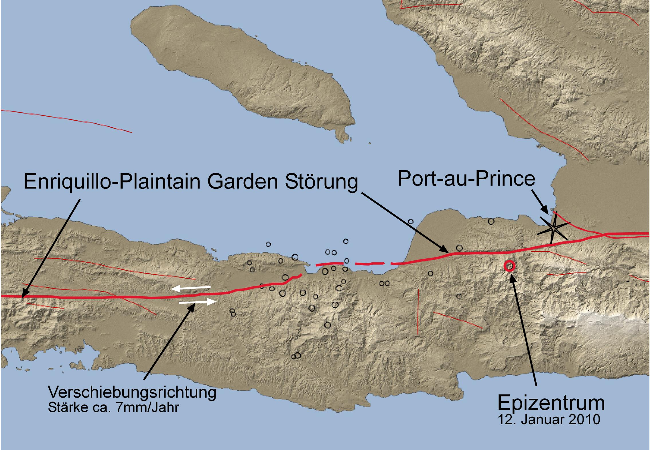
Deutsch: Versification tectonique Carte de la Région de Port-au-Prince mit rem . Januar 2010 (roter Kreis) sowie den Epizentren mehrerer Nachbeben (schwarze Kreise). Eingezeichnet ist die für das beben verantwortliche Enriquillo-Plaintain Garden Störung (rot)
English: simpified tektonik map, schowing the epicenter of the january 12.th quake and the Enriquillo-Plaintain Garden Fault |
| Date | |
| Source | Earth Observatory, verändert |
| Author | Gunnar Ries Amphibol |
| Permission (Reusing this file) |
You must give the original author credit. |
Licensing
[edit]
This file is licensed under the Creative Commons Attribution-Share Alike 3.0 Unported license.
- You are free:
- to share – to copy, distribute and transmit the work
- to remix – to adapt the work
- Under the following conditions:
- attribution – You must give appropriate credit, provide a link to the license, and indicate if changes were made. You may do so in any reasonable manner, but not in any way that suggests the licensor endorses you or your use.
- share alike – If you remix, transform, or build upon the material, you must distribute your contributions under the same or compatible license as the original.
File history
Click on a date/time to view the file as it appeared at that time.
| Date/Time | Thumbnail | Dimensions | User | Comment | |
|---|---|---|---|---|---|
| current | 11:31, 18 January 2010 | | 2,270 × 1,571 (447 KB) | Amphibol (talk | contribs) | Bewegungsrichtung und -stärke der Verwerfung eingezeichnez |
| 13:53, 14 January 2010 |  | 2,270 × 1,571 (432 KB) | Amphibol (talk | contribs) | == Beschreibung == {{Information |Description={{de|Vereinfachte tektonische Karte der Region um Port-au-Prince mit dem Epizentrum des Erdbebens vom 12. Januar 2010 (roter Kreis) sowie den Epizentren mehrerer Nachbeben (schwarze Kreise). Eingezeichnet ist |
You cannot overwrite this file.
File usage on Commons
The following page uses this file:
File usage on other wikis
The following other wikis use this file:
- Usage on en.wikipedia.org
- Usage on fr.wikipedia.org
- Usage on ht.wikipedia.org