File:Hagenow Großsteingräber Binz Granitz (Hof).png
Jump to navigation
Jump to search
No higher resolution available.
Hagenow_Großsteingräber_Binz_Granitz_(Hof).png (419 × 354 pixels, file size: 313 KB, MIME type: image/png)
Captions
Captions
Add a one-line explanation of what this file represents
Summary
[edit].png&action=edit§ion=1)
| Description |
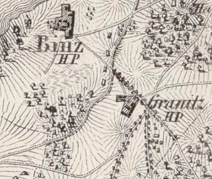
Deutsch: Lage der zerstörten Großsteingräber bei Binz und Granitz (Hof), Insel Rügen
English: Location of the destroyed megalithic tombs at Binz and Granitz (Hof), island of Rügen |
| Date | |
| Source | Friedrich von Hagenow: Special Charte der Insel Rügen. Nach den neuesten Messungen unter Benutzung aller vorhandenen Flurkarten entworfen. Lithographisches Institut des Generalstabes, Berlin 1829 (Online). |
| Author | Friedrich von Hagenow (1797-1865) |
Licensing
[edit].png&action=edit§ion=2)
|
This work is in the public domain in its country of origin and other countries and areas where the copyright term is the author's life plus 70 years or fewer. | |
| This file has been identified as being free of known restrictions under copyright law, including all related and neighboring rights. | |
File history
Click on a date/time to view the file as it appeared at that time.
| Date/Time | Thumbnail | Dimensions | User | Comment | |
|---|---|---|---|---|---|
| current | 17:54, 12 October 2020 | | 419 × 354 (313 KB) | Einsamer Schütze (talk | contribs) | Uploaded a work by Friedrich von Hagenow (1797-1865) from Friedrich von Hagenow: ''Special Charte der Insel Rügen. Nach den neuesten Messungen unter Benutzung aller vorhandenen Flurkarten entworfen.'' Lithographisches Institut des Generalstabes, Berlin 1829 ([https://gallica.bnf.fr/ark:/12148/btv1b53119299d Online]). with UploadWizard |
You cannot overwrite this file.
File usage on Commons
There are no pages that use this file.
File usage on other wikis
The following other wikis use this file:
- Usage on de.wikipedia.org
.png&oldid=822368424)