File:Hafenlohr Diana.jpg
Original file (3,000 × 2,000 pixels, file size: 8.31 MB, MIME type: image/jpeg)
Captions
Summary
[edit]DescriptionHafenlohr Diana.jpg |
Deutsch: Hafenlohr bei Forsthaus Diana im Vogelschutzgebiet 6022-471 "Spessart", FFH-Gebiet 6022-371 "Hochspessart", LSG innerhalb des Naturparks Spessart (ehemals Schutzzone) CDDA 396111
English: 
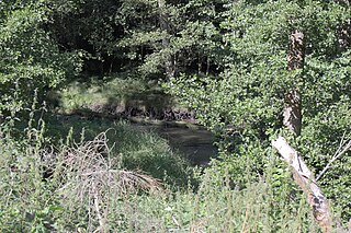
Hafenlohr near forest house Diana in bird reserve 6022-471 'Spessart', SAC 6022-371 'Hochspessart', landscape protection area LSG innerhalb des Naturparks Spessart (ehemals Schutzzone) CDDA 396111 |
Date | |
Source | Own work |
Author | KaiBorgeest |
Camera location | 49° 56′ 35.05″ N, 9° 29′ 02.76″ E | View this and other nearby images on: OpenStreetMap | 49.943070; 9.484100 |
---|
Licensing
[edit]- You are free:
- to share – to copy, distribute and transmit the work
- to remix – to adapt the work
- Under the following conditions:
- attribution – You must give appropriate credit, provide a link to the license, and indicate if changes were made. You may do so in any reasonable manner, but not in any way that suggests the licensor endorses you or your use.
- share alike – If you remix, transform, or build upon the material, you must distribute your contributions under the same or compatible license as the original.
This image was uploaded as part of Wiki Loves Earth 2023.
aragonés ∙ asturianu ∙ azərbaycanca ∙ Bahasa Indonesia ∙ Bahasa Melayu ∙ brezhoneg ∙ català ∙ čeština ∙ Cymraeg ∙ dagbanli ∙ Deutsch ∙ eesti ∙ English ∙ español ∙ euskara ∙ français ∙ galego ∙ hrvatski ∙ italiano ∙ latviešu ∙ Nederlands ∙ norsk ∙ norsk bokmål ∙ português ∙ polski ∙ português do Brasil ∙ română ∙ shqip ∙ sicilianu ∙ slovenščina ∙ svenska ∙ Tagalog ∙ Türkçe ∙ Ελληνικά ∙ беларуская (тарашкевіца) ∙ български ∙ македонски ∙ русский ∙ српски / srpski ∙ українська ∙ ქართული ∙ հայերեն ∙ नेपाली ∙ मराठी ∙ বাংলা ∙ മലയാളം ∙ ไทย ∙ 한국어 ∙ 日本語 ∙ 中文 ∙ 中文(台灣) ∙ 中文(简体) ∙ 中文(繁體) ∙ עברית ∙ اردو ∙ العربية ∙ فارسی ∙ +/− |
File history
Click on a date/time to view the file as it appeared at that time.
Date/Time | Thumbnail | Dimensions | User | Comment | |
---|---|---|---|---|---|
current | 21:02, 29 May 2023 | 3,000 × 2,000 (8.31 MB) | KaiBorgeest (talk | contribs) | Uploaded own work with UploadWizard |
You cannot overwrite this file.
File usage on Commons
The following page uses this file:
Metadata
This file contains additional information such as Exif metadata which may have been added by the digital camera, scanner, or software program used to create or digitize it. If the file has been modified from its original state, some details such as the timestamp may not fully reflect those of the original file. The timestamp is only as accurate as the clock in the camera, and it may be completely wrong.
Image title | |
---|---|
Camera manufacturer | Canon |
Camera model | Canon EOS 77D |
Author | K. Borgeest |
Copyright holder | K. Borgeest |
Exposure time | 1/60 sec (0.016666666666667) |
F-number | f/7.1 |
ISO speed rating | 100 |
Date and time of data generation | 16:50, 29 July 2020 |
Lens focal length | 55 mm |
Latitude | 49° 56′ 35.05″ N |
Longitude | 9° 29′ 2.76″ E |
Altitude | 245.9 meters above sea level |
Orientation | Normal |
Horizontal resolution | 72 dpi |
Vertical resolution | 72 dpi |
Software used | GIMP 2.10.28 |
File change date and time | 23:10, 21 November 2021 |
Y and C positioning | Co-sited |
Exposure Program | Aperture priority |
Exif version | 2.3 |
Date and time of digitizing | 16:50, 29 July 2020 |
Meaning of each component |
|
APEX shutter speed | 6 |
APEX aperture | 5.625 |
APEX exposure bias | 0 |
Metering mode | Center weighted average |
Flash | Flash did not fire |
DateTime subseconds | 06 |
DateTimeOriginal subseconds | 06 |
DateTimeDigitized subseconds | 06 |
Supported Flashpix version | 1 |
Color space | sRGB |
Focal plane X resolution | 6,514.657980456 |
Focal plane Y resolution | 6,734.0067340067 |
Focal plane resolution unit | inches |
Custom image processing | Normal process |
Exposure mode | Auto exposure |
White balance | Auto white balance |
Scene capture type | Standard |
GPS time (atomic clock) | 14:50:18.004 |
Satellites used for measurement | 12 |
Receiver status | Measurement in progress |
Measurement mode | 3-dimensional measurement |
Measurement precision | Poor (2.8) |
Geodetic survey data used | WGS-84 |
GPS date | 29 July 2020 |
GPS tag version | 0.0.3.2 |
Structured data
29 July 2020
49°56'35.05"N, 9°29'2.76"E
0.01666666666666666666 second
7.1
55 millimetre
100
image/jpeg
- Files with coordinates missing SDC location of creation (49° N, 9° E)
- CC-BY-SA-4.0
- Self-published work
- Images from Wiki Loves Earth 2023
- Images from Wiki Loves Earth 2023 in Germany
- Images from Wiki Loves Earth missing SDC location of creation
- Images from Wiki Loves Earth 2023, DE landscape
- Uploaded via Campaign:wle-de
- Unassessed QI candidates