File:Haan-Gruiten Hasenhaus - panoramio.jpg
Jump to navigation
Jump to search

Size of this preview: 800 × 600 pixels. Other resolutions: 320 × 240 pixels | 640 × 480 pixels | 1,024 × 768 pixels | 1,280 × 960 pixels | 2,560 × 1,920 pixels | 4,352 × 3,264 pixels.
Original file (4,352 × 3,264 pixels, file size: 4.05 MB, MIME type: image/jpeg)
Captions
Captions
Add a one-line explanation of what this file represents
Summary
[edit]
| Description |
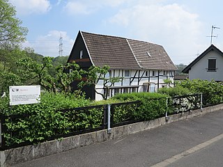
Haan-Gruiten, Vohwinkeler Str. 3 und 5. Die rechte Hälfte des Fachwerk-Gebäudes, Haus Nr. 5, stand schon ein Jahr nach dieser Aufnahme von 2014 nicht mehr, an seiner Stelle wurde 2015 ein Einfamilienhaus errichtet. Die zunächst stehen gebliebene linke Gebäudehälfte, Haus Vohwinkeler Str. 3 (Eingang auf der Rückseite) wurde vermutlich 2020 niedergelegt. Ersetzt wurde es ebenfalls durch ein allerdings deutlich nach links versetztes Einfamilienhaus, das im Herbst 2021 weitgehend vollendet zu sein scheint. |
||
| Date | Taken on 1 May 2014 | ||
| Source | https://web.archive.org/web/20161028165421/http://www.panoramio.com/photo/106514755 | ||
| Author | King Otto | ||
| Permission (Reusing this file) |
This file is licensed under the Creative Commons Attribution-Share Alike 3.0 Unported license. Attribution: King Otto
|
||
| Tags (from Panoramio photo page) | Haan, Hasenhaus |
| Camera location | | View this and other nearby images on: OpenStreetMap |
|---|
| Annotations | This image is annotated: View the annotations at Commons |
File history
Click on a date/time to view the file as it appeared at that time.
| Date/Time | Thumbnail | Dimensions | User | Comment | |
|---|---|---|---|---|---|
| current | 07:51, 7 April 2017 | | 4,352 × 3,264 (4.05 MB) | Panoramio upload bot (talk | contribs) | == {{int:filedesc}} == {{Information |description=Haan-Gruiten Hasenhaus |date={{Taken on|2014-05-01}} |source=http://www.panoramio.com/photo/106514755 |author=[http://www.panoramio.com/user/8277978?with_photo_id=106514755 King Otto] |permission={{cc-b... |
You cannot overwrite this file.
File usage on Commons
There are no pages that use this file.