File:HStAD P23 Nr111, Karte der Grafschaft Mansfeld, 1751.jpg
Jump to navigation
Jump to search

Size of this preview: 689 × 600 pixels. Other resolutions: 276 × 240 pixels | 552 × 480 pixels | 882 × 768 pixels | 1,177 × 1,024 pixels | 1,443 × 1,256 pixels.
Original file (1,443 × 1,256 pixels, file size: 913 KB, MIME type: image/jpeg)
Captions
Captions
Add a one-line explanation of what this file represents
Summary
[edit]| Description |
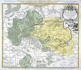
Deutsch: Die Grafschaft Mansfeld Königl. Preuß. und Churfürstl. Sächsische Antheils mit darinnen befindlichen Städten, Dorfschaften, Kupferhütten, Bergwerk-Stollen, Berg-Gränzen und Holzungen. |
||||||||||||||||||||
| Date | |||||||||||||||||||||
| Source |
|
||||||||||||||||||||
| Author |
|
||||||||||||||||||||
| Permission (Reusing this file) |
This file is licensed under the Creative Commons Attribution 3.0 Unported license. Attribution: Hessisches Staatsarchiv Darmstadt, Bestand P 23, Nr. 111 / CC-BY 3.0
|
||||||||||||||||||||

File history
Click on a date/time to view the file as it appeared at that time.
| Date/Time | Thumbnail | Dimensions | User | Comment | |
|---|---|---|---|---|---|
| current | 20:40, 5 January 2020 | | 1,443 × 1,256 (913 KB) | Kochel86 (talk | contribs) | {{Information |description={{de|Die Grafschaft Mansfeld Königl. Preuß. und Churfürstl. Sächsische Antheils mit darinnen befindlichen Städten, Dorfschaften, Kupferhütten, Bergwerk-Stollen, Berg-Gränzen und Holzungen.}} |date={{date|1751}} |source={{Institution|wikidata=Q1616000}} |author={{Creator:Tobias Mayer|Workshop of}} |permission={{cc-by-3.0|attribution=Hessisches Staatsarchiv Darmstadt, Bestand P 23, Nr. 111 / CC-BY 3.0}} |other versions= }} Category:History of Mansfeld Land [[Cat... |
You cannot overwrite this file.
File usage on Commons
The following page uses this file: