File:HRR 1648 Tirol.png
Jump to navigation
Jump to search

Size of this preview: 782 × 600 pixels. Other resolutions: 313 × 240 pixels | 626 × 480 pixels | 1,002 × 768 pixels | 1,280 × 982 pixels | 1,973 × 1,513 pixels.
Original file (1,973 × 1,513 pixels, file size: 521 KB, MIME type: image/png)
Captions
Captions
Add a one-line explanation of what this file represents
| Description |
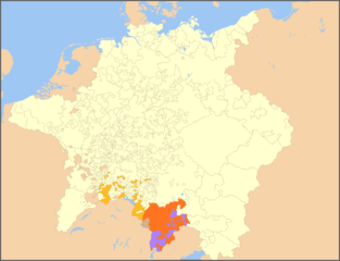
English: Map of the Holy Roman Empire, 1648, with Tyrol highlighted. Colours used:
Deutsch: Karte Tirols im Heiligen Römischen Reich (1648). Farblegende:
|
| Source |
modified from File:Holy Roman Empire 1648 Ecclesiastical.png; boundaries inferred from Tirol-Atlas (edited by A. Leidlmair, Innsbruck: Universitätsverlag Wagner, 1985), Part F - Geschichte (F. Dörrer, P.W. Haider, F. Huter, W. Keller & W. Leitner), specifically maps F6 (Territoriale Entwicklung, F. Huter & W. Keller) and F9 (Verwaltungsgliederung 1766, F. Dörrer & W. Keller) |
| Author | Roke (map), Hanno Sandvik (addition of colours) |
| Permission (Reusing this file) |
released by the author under GNU |

|
Permission is granted to copy, distribute and/or modify this document under the terms of the GNU Free Documentation License, Version 1.2 or any later version published by the Free Software Foundation; with no Invariant Sections, no Front-Cover Texts, and no Back-Cover Texts. A copy of the license is included in the section entitled GNU Free Documentation License. |
| This file is licensed under the Creative Commons Attribution-Share Alike 3.0 Unported license. | ||
| ||
| This licensing tag was added to this file as part of the GFDL licensing update. |
File history
Click on a date/time to view the file as it appeared at that time.
| Date/Time | Thumbnail | Dimensions | User | Comment | |
|---|---|---|---|---|---|
| current | 07:23, 16 May 2009 | | 1,973 × 1,513 (521 KB) | Hanno (talk | contribs) | {{Information |Description={{en|Map of the Holy Roman Empire, 1648, with the territories belonging to the princely county of Tyrol highlighted}} {{de|Karte der gefürsteten Grafschaft Tirol im Heiligen Römischen Reich (1648)}} |Source=modified from [[:Fi |
You cannot overwrite this file.
File usage on Commons
There are no pages that use this file.
File usage on other wikis
The following other wikis use this file:
- Usage on es.wikipedia.org
- Usage on fr.wikipedia.org
- Usage on it.wikipedia.org