File:HIGHFIELDS, EAST AMWELL TOWNSHIP, HUNTERDON COUNTY (cropped).jpg
![File:HIGHFIELDS, EAST AMWELL TOWNSHIP, HUNTERDON COUNTY (cropped).jpg](https://upload.wikimedia.org/wikipedia/commons/thumb/2/2d/HIGHFIELDS%2C_EAST_AMWELL_TOWNSHIP%2C_HUNTERDON_COUNTY_%28cropped%29.jpg/800px-HIGHFIELDS%2C_EAST_AMWELL_TOWNSHIP%2C_HUNTERDON_COUNTY_%28cropped%29.jpg?20150814075636)
Original file (2,506 × 1,391 pixels, file size: 523 KB, MIME type: image/jpeg)
Captions
Captions
Summary
[edit]DescriptionHIGHFIELDS, EAST AMWELL TOWNSHIP, HUNTERDON COUNTY (cropped).jpg |
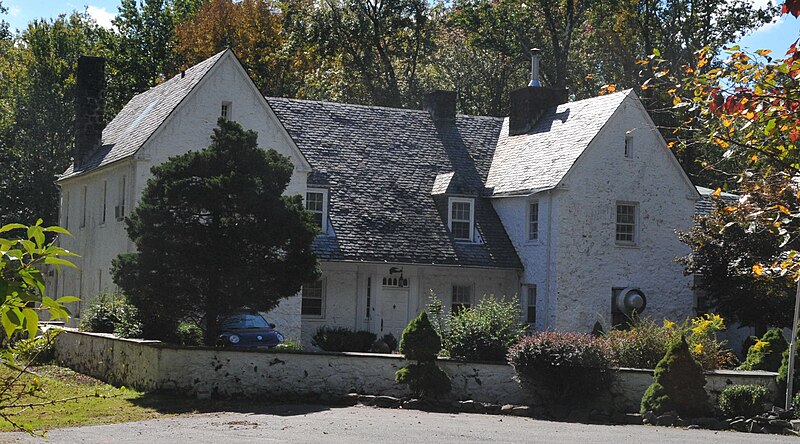
English: THE FORMER LINDBERGH ESTATE AND THE SCENE OF THE 1932 KIDNAPPING OF CHARLES LINDBERGH AND ANNE MORROW LINDBERGH’S 20 MONTH OLD SON. THE BABY WAS ABDUCTED FROM ONE OF THE SECOND STORY WINDOWS BY USE OF A LADDER. THIS KIDNAPPING RESULTED IN THE CRIME BECOMING A FEDERAL CRIME INVESTIGATED HENCEFORTH BY THE FBI |
Date | Taken on 22 March 2007, 14:17:40 |
Source | Own work |
Author | Jerrye & Roy Klotz, MD |
THIS SITE IS A BIT OF AN ENIGMA BECAUSE IT IS NOW THE ALBERT ELIAS SCHOOL OWNED BY THE STATE OF NEW JERSEY. IT IS OCCASIONALLY OPENED FOR TOURS BUT IT IS DOWN A LONG ROAD SIGNPOSTED AS STATE PROPERTY WITH NO TRESPASSING BUT NO ONE BOTHERED US AND THERE WERE A FAIR NUMBER OF CARS IN THE PARKING LOT
Licensing
[edit]![w:en:Creative Commons](https://upload.wikimedia.org/wikipedia/commons/thumb/7/79/CC_some_rights_reserved.svg/90px-CC_some_rights_reserved.svg.png)
![attribution](https://upload.wikimedia.org/wikipedia/commons/thumb/1/11/Cc-by_new_white.svg/24px-Cc-by_new_white.svg.png)
![share alike](https://upload.wikimedia.org/wikipedia/commons/thumb/d/df/Cc-sa_white.svg/24px-Cc-sa_white.svg.png)
- You are free:
- to share – to copy, distribute and transmit the work
- to remix – to adapt the work
- Under the following conditions:
- attribution – You must give appropriate credit, provide a link to the license, and indicate if changes were made. You may do so in any reasonable manner, but not in any way that suggests the licensor endorses you or your use.
- share alike – If you remix, transform, or build upon the material, you must distribute your contributions under the same or compatible license as the original.
![]() |
This image was uploaded as part of Wiki Loves Monuments 2013.
Afrikaans ∙ Alemannisch ∙ azərbaycanca ∙ Bahasa Indonesia ∙ Bahasa Melayu ∙ Bikol Central ∙ bosanski ∙ brezhoneg ∙ català ∙ čeština ∙ Cymraeg ∙ dansk ∙ davvisámegiella ∙ Deutsch ∙ eesti ∙ English ∙ español ∙ Esperanto ∙ euskara ∙ français ∙ Frysk ∙ Gaeilge ∙ galego ∙ hrvatski ∙ Ido ∙ italiano ∙ latviešu ∙ Lëtzebuergesch ∙ Malagasy ∙ magyar ∙ Malti ∙ Nederlands ∙ norsk ∙ norsk nynorsk ∙ norsk bokmål ∙ polski ∙ português ∙ português do Brasil ∙ română ∙ shqip ∙ sicilianu ∙ slovenčina ∙ slovenščina ∙ suomi ∙ svenska ∙ Tagalog ∙ Türkçe ∙ Yorùbá ∙ Zazaki ∙ Ελληνικά ∙ беларуская ∙ беларуская (тарашкевіца) ∙ български ∙ кыргызча ∙ македонски ∙ русский ∙ српски / srpski ∙ українська ∙ ქართული ∙ հայերեն ∙ नेपाली ∙ हिन्दी ∙ বাংলা ∙ മലയാളം ∙ ไทย ∙ 한국어 ∙ +/− |
![]() |
![]() |
This is an image of a place or building that is listed on the National Register of Historic Places in the United States of America. Its reference number is 94001096. |
![]() |
This file has been extracted from another file : HIGHFIELDS, EAST AMWELL TOWNSHIP, HUNTERDON COUNTY.jpg |
File history
Click on a date/time to view the file as it appeared at that time.
Date/Time | Thumbnail | Dimensions | User | Comment | |
---|---|---|---|---|---|
current | 07:56, 14 August 2015 | ![]() | 2,506 × 1,391 (523 KB) | Renamed user mou89p43twvqcvm8ut9w3 (talk | contribs) | File:HIGHFIELDS, EAST AMWELL TOWNSHIP, HUNTERDON COUNTY.jpg cropped 10 % horizontally and 25 % vertically using CropTool with lossless mode. |
You cannot overwrite this file.
File usage on Commons
There are no pages that use this file.
File usage on other wikis
The following other wikis use this file:
Metadata
This file contains additional information such as Exif metadata which may have been added by the digital camera, scanner, or software program used to create or digitize it. If the file has been modified from its original state, some details such as the timestamp may not fully reflect those of the original file. The timestamp is only as accurate as the clock in the camera, and it may be completely wrong.
Camera manufacturer | NIKON CORPORATION |
---|---|
Camera model | NIKON D3 |
Exposure time | 1/1,000 sec (0.001) |
F-number | f/16 |
ISO speed rating | 1,600 |
Date and time of data generation | 14:17, 22 March 2007 |
Lens focal length | 38 mm |
Width | 2,784 px |
Height | 1,848 px |
Bits per component |
|
Pixel composition | RGB |
Orientation | Normal |
Number of components | 3 |
Horizontal resolution | 278.4 dpi |
Vertical resolution | 278.4 dpi |
Software used | Adobe Photoshop Elements 11.0 Macintosh |
File change date and time | 20:01, 28 September 2013 |
Y and C positioning | Co-sited |
Exposure Program | Normal program |
Exif version | 2.21 |
Date and time of digitizing | 14:17, 22 March 2007 |
Meaning of each component |
|
Image compression mode | 4 |
APEX shutter speed | 9.9657843770174 |
APEX aperture | 8 |
APEX exposure bias | −0.33333333333333 |
Maximum land aperture | 4.2086733504313 APEX (f/4.3) |
Metering mode | Pattern |
Light source | Unknown |
Flash | Flash did not fire |
DateTime subseconds | 50 |
DateTimeOriginal subseconds | 50 |
DateTimeDigitized subseconds | 50 |
Supported Flashpix version | 1 |
Color space | sRGB |
Sensing method | One-chip color area sensor |
File source | Digital still camera |
Scene type | A directly photographed image |
Custom image processing | Normal process |
Exposure mode | Auto exposure |
White balance | Auto white balance |
Digital zoom ratio | 1.53 |
Focal length in 35 mm film | 57 mm |
Scene capture type | Standard |
Scene control | High gain up |
Contrast | Normal |
Saturation | Normal |
Sharpness | Normal |
Subject distance range | Unknown |
GPS tag version | 2.2.0.0 |
Lens used | 18.0-200.0 mm f/3.5-5.6 |
Serial number of camera | 2061752 |
Date metadata was last modified | 16:01, 28 September 2013 |
Unique ID of original document | 8B4E79C0ADE5A161F30AE8A130D3E389 |
Structured data
Items portrayed in this file
depicts
some value
22 March 2007
0.001 second
16
38 millimetre
1,600
image/jpeg
- United States photographs taken on 2007-03-22
- CC-BY-SA-3.0
- Self-published work
- Images from Wiki Loves Monuments 2013
- Images from Wiki Loves Monuments 2013 in the United States
- Images from Wiki Loves Monuments missing SDC depicts
- Images from Wiki Loves Monuments missing SDC location of creation
- National Register of Historic Places with known IDs
- National Register of Historic Places missing SDC depicts
- National Register of Historic Places missing SDC location of creation
- Extracted images
- WLM 2013 United States unreviewed
- Photographs by User:KLOTZ