File:H1N1 Italy Map.svg
Jump to navigation
Jump to search

Size of this PNG preview of this SVG file: 508 × 599 pixels. Other resolutions: 203 × 240 pixels | 407 × 480 pixels | 651 × 768 pixels | 868 × 1,024 pixels | 1,736 × 2,048 pixels | 735 × 867 pixels.
Original file (SVG file, nominally 735 × 867 pixels, file size: 51 KB)
Captions
Captions
Add a one-line explanation of what this file represents
Summary
[edit]
| Description |
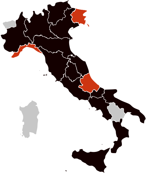
English: A map of the regions of Italy showing the confirmed cases of the 2009 H1N1 flu virus. Swine Flu in Italy Update 3
Português: Mapa da pandemia de gripe de 2009 na Itália.
Mortes
Casos confirmados
Casos suspeitos
Sem suspeitas |
| Date | 11/06/2009 |
| Source | Own work |
| Author | Allstrak |
| Other versions | H1N1 Italy Map.svg |
Licensing
[edit]
I, the copyright holder of this work, hereby publish it under the following licenses:
This file is licensed under the Creative Commons Attribution-Share Alike 3.0 Unported license.
- You are free:
- to share – to copy, distribute and transmit the work
- to remix – to adapt the work
- Under the following conditions:
- attribution – You must give appropriate credit, provide a link to the license, and indicate if changes were made. You may do so in any reasonable manner, but not in any way that suggests the licensor endorses you or your use.
- share alike – If you remix, transform, or build upon the material, you must distribute your contributions under the same or compatible license as the original.

|
Permission is granted to copy, distribute and/or modify this document under the terms of the GNU Free Documentation License, Version 1.2 or any later version published by the Free Software Foundation; with no Invariant Sections, no Front-Cover Texts, and no Back-Cover Texts. A copy of the license is included in the section entitled GNU Free Documentation License. |
You may select the license of your choice.
File history
Click on a date/time to view the file as it appeared at that time.
| Date/Time | Thumbnail | Dimensions | User | Comment | |
|---|---|---|---|---|---|
| current | 14:41, 23 November 2009 | | 735 × 867 (51 KB) | Hariboneagle927 (talk | contribs) | update |
| 14:57, 18 November 2009 |  | 735 × 867 (51 KB) | Hariboneagle927 (talk | contribs) | update | |
| 01:45, 24 September 2009 |  | 735 × 867 (51 KB) | Fonadier (talk | contribs) | Updating map | |
| 06:02, 4 September 2009 |  | 735 × 867 (117 KB) | Airon90 (talk | contribs) | Reverted to version as of 22:07, 11 June 2009 http://www.corriere.it/notizie-ultima-ora/Cronache/Nuova-influenza-Cotugno-smentisce-voci-morte-paziente/02-09-2009/1-A_000044189.shtml | |
| 11:12, 2 September 2009 |  | 735 × 867 (69 KB) | RaminusFalcon (talk | contribs) | registered the first death in Campania | |
| 22:07, 11 June 2009 |  | 735 × 867 (117 KB) | Dcoetzee (talk | contribs) | Updated version from File:H1N1 Italy Map2.svg | |
| 02:10, 30 May 2009 |  | 1,200 × 1,500 (700 KB) | Notelitten~commonswiki (talk | contribs) | Added confirmed case in venice added confirmed case in Massa | |
| 13:03, 29 April 2009 |  | 1,200 × 1,500 (700 KB) | Avala (talk | contribs) | ||
| 17:16, 27 April 2009 |  | 1,200 × 1,500 (698 KB) | Allstrak (talk | contribs) | removed an area; negative suspect | |
| 12:52, 27 April 2009 |  | 1,200 × 1,500 (698 KB) | Allstrak (talk | contribs) | {{Information |Description=A map of Italty about the H1N1 flu |Source=self-made |Date=27th arpil, 2009 |Author= Allstrak |Permission= |other_versions= }} Category:maps Category:Swine flu |
You cannot overwrite this file.
File usage on Commons
The following page uses this file:
File usage on other wikis
The following other wikis use this file:
- Usage on ar.wikipedia.org
- Usage on en.wikipedia.org
- Usage on es.wikipedia.org
- Usage on fr.wikipedia.org
- Usage on it.wikipedia.org
- Usage on nl.wikipedia.org