File:Höhenschichten Karte des Harzgebirges, Kartenausschnitt Goldene Aue.jpg
Jump to navigation
Jump to search

Size of this preview: 799 × 198 pixels. Other resolutions: 320 × 79 pixels | 640 × 159 pixels | 1,024 × 254 pixels | 1,280 × 317 pixels | 5,692 × 1,411 pixels.
Original file (5,692 × 1,411 pixels, file size: 2.59 MB, MIME type: image/jpeg)
Captions
Captions
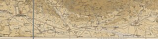
Höhenschichten Karte des Harzgebirges, lithog. Institut (Berlin) Kartenausschnitt Goldene Aue
Summary
[edit]| Description |
English: Höhenschichten Karte des Harzgebirges, lithog. Institut (Berlin) Kartenausschnitt Goldene Aue |
||||
| Date | 19. jahrhundert | ||||
| Source | |||||
| Author | lithog. Institut Berlin | ||||
| Permission (Reusing this file) |
|
||||
| Other versions |
This file was derived from: Höhenschichten Karte des Harzgebirges... - btv1b53020971k.jpg |

Licensing
[edit]
File history
Click on a date/time to view the file as it appeared at that time.
| Date/Time | Thumbnail | Dimensions | User | Comment | |
|---|---|---|---|---|---|
| current | 10:32, 14 June 2024 | 5,692 × 1,411 (2.59 MB) | Profilleiste (talk | contribs) | Uploaded own work with UploadWizard |
You cannot overwrite this file.
File usage on Commons
There are no pages that use this file.