File:Hálslón.jpg
From Wikimedia Commons, the free media repository
Jump to navigation
Jump to search
![File:Hálslón.jpg](https://upload.wikimedia.org/wikipedia/commons/thumb/3/39/H%C3%A1lsl%C3%B3n.jpg/800px-H%C3%A1lsl%C3%B3n.jpg?20090919050817)
Size of this preview: 800 × 531 pixels. Other resolutions: 320 × 213 pixels | 640 × 425 pixels | 1,024 × 680 pixels.
Original file (1,024 × 680 pixels, file size: 243 KB, MIME type: image/jpeg)
File information
Structured data
Captions
Captions
Add a one-line explanation of what this file represents
DescriptionHálslón.jpg |
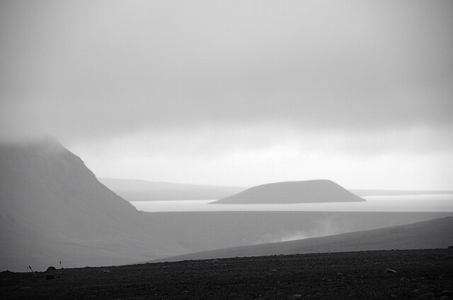
Deutsch: Der Hálslón ist mit 57 km² Fläche der größte Stausee des Wasserkraftwerks Kárahnjúkavirkjun. Der Fluss Jökulsá á Brú wird durch drei Staudämme mit einer Gesamtlänge von 2.900 m und einer Höhe von bis zu 198 m aufgestaut. Vom Sandfell, einem 682 m hohen Berg, ragt nur noch die Spitze als Insel aus dem See.
Íslenska: Hálslón er 57 km2 að flatarmáli. Það er myndað með 2900 m langri og 198 m hárri stíflu í Jökulsá á Brú. Sandfell, sem er 682 m hátt yfir sjó er orðið að eyju í lóninu. |
||||
Date | |||||
Source | originally posted to Flickr as Hálslón | ||||
Author |
|
||||
Permission (Reusing this file) |
![]() ![]() ![]() This file is licensed under the Creative Commons Attribution-Share Alike 2.0 Generic license.
|
File history
Click on a date/time to view the file as it appeared at that time.
Date/Time | Thumbnail | Dimensions | User | Comment | |
---|---|---|---|---|---|
current | 05:08, 19 September 2009 | ![]() | 1,024 × 680 (243 KB) | Flickr upload bot (talk | contribs) | Uploaded from http://flickr.com/photo/29680252@N05/3310154764 using Flickr upload bot |
You cannot overwrite this file.
File usage on Commons
There are no pages that use this file.
Metadata
This file contains additional information such as Exif metadata which may have been added by the digital camera, scanner, or software program used to create or digitize it. If the file has been modified from its original state, some details such as the timestamp may not fully reflect those of the original file. The timestamp is only as accurate as the clock in the camera, and it may be completely wrong.
Camera manufacturer | NIKON CORPORATION |
---|---|
Camera model | NIKON D300 |
Exposure time | 1/100 sec (0.01) |
F-number | f/5.6 |
ISO speed rating | 200 |
Date and time of data generation | 20:07, 10 September 2008 |
Lens focal length | 130 mm |
Altitude | 712 meters above sea level |
Orientation | Normal |
Horizontal resolution | 300 dpi |
Vertical resolution | 300 dpi |
Software used | Capture NX 2.1.1 W |
File change date and time | 22:22, 25 February 2009 |
Y and C positioning | Centered |
Exposure Program | Normal program |
Exif version | 2.2 |
Date and time of digitizing | 20:07, 10 September 2008 |
APEX exposure bias | 0 |
Maximum land aperture | 5 APEX (f/5.66) |
Metering mode | Pattern |
Light source | Unknown |
Flash | Flash did not fire |
DateTime subseconds | 60 |
DateTimeOriginal subseconds | 60 |
DateTimeDigitized subseconds | 60 |
Color space | sRGB |
Sensing method | One-chip color area sensor |
Custom image processing | Normal process |
Exposure mode | Auto exposure |
White balance | Auto white balance |
Digital zoom ratio | 1 |
Focal length in 35 mm film | 195 mm |
Scene capture type | Standard |
Contrast | Normal |
Saturation | Normal |
Sharpness | Normal |
Subject distance range | Unknown |
North or south latitude | North latitude |
East or west longitude | West longitude |
Satellites used for measurement | 12 |
GPS date | 10 September 2008 |