File:Guyana-CIA WFB Map-fr.png
Jump to navigation
Jump to search
No higher resolution available.
Guyana-CIA_WFB_Map-fr.png (326 × 350 pixels, file size: 48 KB, MIME type: image/png)
Captions
Captions
Add a one-line explanation of what this file represents
Summary
[edit]| Description |
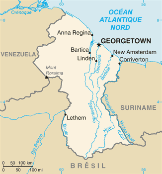
Français : Carte du Guyana.
English: Map of Guyana.
Italiano: Mappa della Guyana. |
|||
| Date | ||||
| Source | https://www.cia.gov/library/publications/the-world-factbook/geos/gy.html | |||
| Author | Directorate of Intelligence, CIA, edited by SyntaxTerror | |||
| Permission (Reusing this file) |
|
|||
| Other versions |
|


File history
Click on a date/time to view the file as it appeared at that time.
| Date/Time | Thumbnail | Dimensions | User | Comment | |
|---|---|---|---|---|---|
| current | 13:19, 21 September 2022 | | 326 × 350 (48 KB) | SyntaxTerror (talk | contribs) | == {{int:filedesc}} == {{Information |Description = {{fr|1=Carte du Guyana.}} {{en|1=Map of Guyana.}} {{it|1=Mappa della Guyana.}} |Source =https://www.cia.gov/library/publications/the-world-factbook/geos/gy.html |Author =Directorate of Intelligence, CIA, edited by {{u|SyntaxTerror}} |Date =2022-09-21 |Permission ={{PD-USGov-CIA-WF}} |other_versions = <gallery> Guyana-CIA WFB Map.png|lang=en|{{#language:en}} </gallery> }} [[Category:CIA World Factbook maps o... |
You cannot overwrite this file.
File usage on Commons
The following page uses this file:
File usage on other wikis
The following other wikis use this file:
- Usage on fr.wikipedia.org