File:Gun Laying mat.jpg
Gun_Laying_mat.jpg (348 × 261 pixels, file size: 37 KB, MIME type: image/jpeg)
Captions
Captions
Summary
[edit]
| Description |
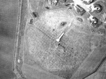
English: Aerial photo of the gun laying mat on the south side of Moor Lane at Cleadon, Jarrow taken on 27 March 1946 by the RAF.
The GL mats were installed starting in early 1941 to correct a problem noticed when using the British Army's early GL Mk. I radar systems. The signal was sent out in a broad pattern and would strike the ground in front of the station to be reflected back in the sky. The same problem occurred on reception, with signals received directly as well as reflecting from nearby ground. The mixed signal was randomized by the lay of the land, which made calibration almost impossible. The mats provided an optically flat area that solved this problem. The mats consisted of 240 rolls of 2-inch chicken wire suspected on the ground about 5 feet on a cats-cradle of metal wires supported on wooden poles. The outline of the mat is the octagonal shape centred in the image. The white square object in the centre is a platform that raised the receiver antenna to the right altitude above the mat. The rectangular portion running to the top right is a ramp that allowed the carriage-born antenna to be backed up onto the platform. The round objects in the upper right are the AA gun emplacements. The radar equipment is missing in this photo. Either the site has been deactivated, or it has been replaced by a more modern radar system that did not require the mat. The grey rectangular object in the upper centre-left may be a GL Mk. III, or more likely a US SCR-584. |
| Date | |
| Source | https://web.archive.org/web/20080211035431/http://www.english-heritage.org.uk/server/show/ConMediaFile.28091 |
| Author | RAF |
| Camera location | | View this and other nearby images on: OpenStreetMap |
|---|
Licensing
[edit]
This work created by the United Kingdom Government is in the public domain.
This is because it is one of the following:
HMSO has declared that the expiry of Crown Copyrights applies worldwide (ref: HMSO Email Reply)
|
 |
File history
Click on a date/time to view the file as it appeared at that time.
| Date/Time | Thumbnail | Dimensions | User | Comment | |
|---|---|---|---|---|---|
| current | 12:06, 12 November 2014 | | 348 × 261 (37 KB) | Maury Markowitz (talk | contribs) | User created page with UploadWizard |
You cannot overwrite this file.
File usage on Commons
The following page uses this file:
File usage on other wikis
The following other wikis use this file:
- Usage on en.wikipedia.org