File:Gun Emplacement near Bowers Hall - geograph.org.uk - 65806.jpg
Jump to navigation
Jump to search
No higher resolution available.
Gun_Emplacement_near_Bowers_Hall_-_geograph.org.uk_-_65806.jpg (640 × 482 pixels, file size: 84 KB, MIME type: image/jpeg)
Captions
Captions
Add a one-line explanation of what this file represents
Summary
[edit]
| Description |
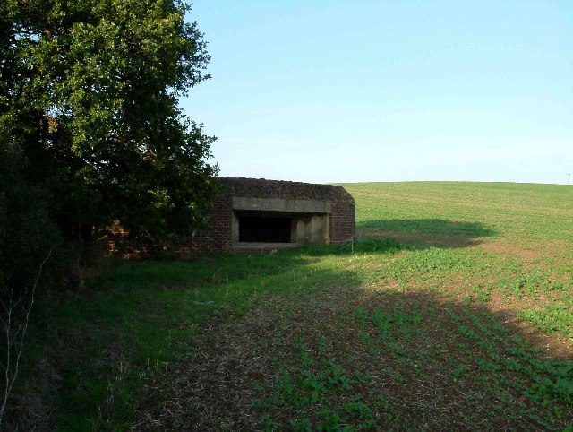
English: Gun Emplacement near Bowers Hall. This gun emplacement seems inordinately large to protect the LT&S Railway. The River Thames is 5km away and there is nothing in between but marshes, one can only speculate why one would need a brick built blockhouse to protect what in the 1940s would have been close to the middle of nowhere. Further information received from a visitor to the page reveals this bunker was part of the GHQ line see GHQ_Line |
| Date | |
| Source | From geograph.org.uk |
| Author | Glyn Baker |
| Attribution (required by the license) | Glyn Baker / Gun Emplacement near Bowers Hall / |
| Object location | | View this and other nearby images on: OpenStreetMap |
|---|
_&language=en)
Licensing
[edit]

|
This image was taken from the Geograph project collection. See this photograph's page on the Geograph website for the photographer's contact details. The copyright on this image is owned by Glyn Baker and is licensed for reuse under the Creative Commons Attribution-ShareAlike 2.0 license.
|
This file is licensed under the Creative Commons Attribution-Share Alike 2.0 Generic license.
Attribution: Glyn Baker
- You are free:
- to share – to copy, distribute and transmit the work
- to remix – to adapt the work
- Under the following conditions:
- attribution – You must give appropriate credit, provide a link to the license, and indicate if changes were made. You may do so in any reasonable manner, but not in any way that suggests the licensor endorses you or your use.
- share alike – If you remix, transform, or build upon the material, you must distribute your contributions under the same or compatible license as the original.
- Remove redundant categories and try to put this image in the most specific category/categories
- Remove this template
- The location categories are based on information from this geonames tool and this OpenStreetMap tool combined with a database. You can also have a look at this tool from mysociety.
- The topic category from Geograph was Wartime relics (find similar images relics at Geograph)
File history
Click on a date/time to view the file as it appeared at that time.
| Date/Time | Thumbnail | Dimensions | User | Comment | |
|---|---|---|---|---|---|
| current | 15:51, 30 January 2010 | | 640 × 482 (84 KB) | GeographBot (talk | contribs) | == {{int:filedesc}} == {{Information |description={{en|1=Gun Emplacement near Bowers Hall. This gun emplacement seems inordinately large to protect the LT&S Railway. The River Thames is 5km away and there is nothing in between but marshes, one can only sp |
You cannot overwrite this file.
File usage on Commons
There are no pages that use this file.
File usage on other wikis
The following other wikis use this file:
- Usage on en.wikipedia.org
- Usage on nl.wikipedia.org