File:Gujarat (India)-satellite.jpg
Jump to navigation
Jump to search
Size of this preview: 741 × 600 pixels. Other resolutions: 297 × 240 pixels | 593 × 480 pixels | 767 × 621 pixels.
Original file (767 × 621 pixels, file size: 66 KB, MIME type: image/jpeg)
Captions
Captions
Add a one-line explanation of what this file represents
| Description |
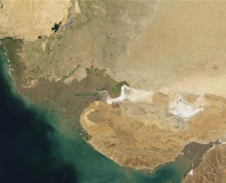
Polski: Solniska Rann of Kutch na granicy indyjskiego stanu Gudźarat z Pakistanem. Zaznaczono rzekę Indus i przybliżone położenie wyschniętej rzeki Saraswati |
| Date | 24 April 2005 (original upload date) |
| Source | based on: NASA image; Transferred from pl.wikipedia; transferred to Commons by User:Masur using CommonsHelper. |
| Author | Original uploader was Julo at pl.wikipedia |
| Permission (Reusing this file) |
PD-NASA. |
Licensing
[edit]-satellite.jpg&action=edit§ion=1)
| This file is in the public domain in the United States because it was solely created by NASA. NASA copyright policy states that "NASA material is not protected by copyright unless noted". (See Template:PD-USGov, NASA copyright policy page or JPL Image Use Policy.) | ||
 |
Warnings:
|
Original upload log
[edit]-satellite.jpg&action=edit§ion=2)
The original description page was here. All following user names refer to pl.wikipedia.
- 2005-04-24 01:00 Julo 767×621× (67527 bytes) Solniska Rann of Kutch na granicy indyjskiego stanu Gudźarat z Pakistanem. Zaznaczono rzekę Indus i przybliżone położenie wyschniętej rzeki Saraswati Wykonano na podstawie fotografii NASA {{PD}}
File history
Click on a date/time to view the file as it appeared at that time.
| Date/Time | Thumbnail | Dimensions | User | Comment | |
|---|---|---|---|---|---|
| current | 04:03, 18 May 2009 | | 767 × 621 (66 KB) | File Upload Bot (Magnus Manske) (talk | contribs) | {{BotMoveToCommons|pl.wikipedia|year={{subst:CURRENTYEAR}}|month={{subst:CURRENTMONTHNAME}}|day={{subst:CURRENTDAY}}}} {{Information |Description={{pl|Solniska Rann of Kutch na granicy indyjskiego stanu Gudźarat z Pakistanem. Zaznaczono rzekę Indus i p |
You cannot overwrite this file.
File usage on Commons
There are no pages that use this file.
File usage on other wikis
The following other wikis use this file:
- Usage on id.wikipedia.org
- Usage on jv.wikipedia.org
- Usage on pl.wikipedia.org
-satellite.jpg&oldid=910868428)