File:Guinea Regions map.png
Jump to navigation
Jump to search
Size of this preview: 790 × 600 pixels. Other resolutions: 316 × 240 pixels | 632 × 480 pixels | 1,012 × 768 pixels | 1,280 × 972 pixels | 1,500 × 1,139 pixels.
Original file (1,500 × 1,139 pixels, file size: 667 KB, MIME type: image/png)
Captions
Captions
Add a one-line explanation of what this file represents
Summary
[edit]
| Description |
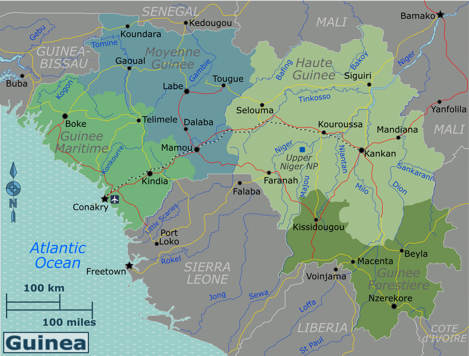
English: Map of Guinea. |
||||
| Date | |||||
| Source |
Own work based on United Nations Cartographic Section Guinea Map.
|
||||
| Author | Burmesedays | ||||
| Other versions | Guinea Regions map.svg |
Licensing
[edit]
This file is licensed under the Creative Commons Attribution-Share Alike 3.0 Unported license.
- You are free:
- to share – to copy, distribute and transmit the work
- to remix – to adapt the work
- Under the following conditions:
- attribution – You must give appropriate credit, provide a link to the license, and indicate if changes were made. You may do so in any reasonable manner, but not in any way that suggests the licensor endorses you or your use.
- share alike – If you remix, transform, or build upon the material, you must distribute your contributions under the same or compatible license as the original.
Original upload log
[edit]
| This file was imported from Wikivoyage WTS. |
The original description page was here. All following user names refer to wts.wikivoyage-old.
- 2010-02-11 11:44 (WT-shared) Burmesedays[dead link] 2399×1822 (1162590 bytes) {{Imagecredit|credit=[[user:burmesedays]], [http://www.un.org/Depts/Cartographic/map/profile/guinea.pdf United Nations Cartographic Section (Import from wikitravel.org/shared)
- 2010-02-11 12:01 (WT-shared) Burmesedays[dead link] 2500×1898 (1233892 bytes) (Import from wikitravel.org/shared)
- 2010-04-25 07:19 (WT-shared) Burmesedays[dead link] 2527×1919 (1279899 bytes) (Import from wikitravel.org/shared)
File history
Click on a date/time to view the file as it appeared at that time.
| Date/Time | Thumbnail | Dimensions | User | Comment | |
|---|---|---|---|---|---|
| current | 21:38, 7 August 2014 | | 1,500 × 1,139 (667 KB) | Saqib (talk | contribs) | typo |
| 20:57, 16 December 2012 |  | 2,527 × 1,919 (1.22 MB) | OgreBot (talk | contribs) | (BOT): Reverting to most recent version before archival | |
| 20:57, 16 December 2012 |  | 2,500 × 1,898 (1.18 MB) | OgreBot (talk | contribs) | (BOT): Uploading old version of file from wts.wikivoyage; originally uploaded on 2010-02-11 12:01:11 by (WT-shared) Burmesedays | |
| 20:57, 16 December 2012 |  | 2,399 × 1,822 (1.11 MB) | OgreBot (talk | contribs) | (BOT): Uploading old version of file from wts.wikivoyage; originally uploaded on 2010-02-11 11:44:10 by (WT-shared) Burmesedays | |
| 23:57, 17 November 2012 |  | 2,527 × 1,919 (1.22 MB) | MGA73bot2 (talk | contribs) | {{BotMoveToCommons|wts.oldwikivoyage|year={{subst:CURRENTYEAR}}|month={{subst:CURRENTMONTHNAME}}|day={{subst:CURRENTDAY}}}} == {{int:filedesc}} == {{Information |description=Map of Guinea. Map of Guinea, Guinea * Map of: Guinea¤ |date=February 11th 20... |
You cannot overwrite this file.
File usage on Commons
There are no pages that use this file.
File usage on other wikis
The following other wikis use this file:
- Usage on cs.wikivoyage.org
- Usage on en.wikivoyage.org
- Usage on fr.wikivoyage.org
- Usage on he.wikivoyage.org
- Usage on incubator.wikimedia.org
- Usage on it.wikivoyage.org
- Usage on nl.wikivoyage.org
- Usage on uk.wikivoyage.org
- Usage on vi.wikivoyage.org
- Usage on zh.wikivoyage.org