File:Guadalupe with the adjacent islands. LOC 2010593356.jpg
Jump to navigation
Jump to search

Size of this preview: 800 × 509 pixels. Other resolutions: 320 × 204 pixels | 640 × 407 pixels | 1,024 × 652 pixels | 1,280 × 815 pixels | 2,560 × 1,629 pixels | 3,319 × 2,112 pixels.
Original file (3,319 × 2,112 pixels, file size: 818 KB, MIME type: image/jpeg)
Captions
Captions
Add a one-line explanation of what this file represents
Summary
[edit]| Description |
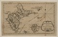
English: Relief shown pictorially and by hachures. From Grand Magazine of Magazines. March 1759, v. 2. Prime meridian: Ferro. LC Maps of North America, 1750-1789, 2012 Available also through the Library of Congress Web site as a raster image. |
||
| Title | Guadalupe with the adjacent islands. | ||
| Shelf ID | G5070 1759 .G8 | ||
| Date | |||
| Source | https://www.loc.gov/item/2010593356/ | ||
| Author | Unknown author | ||
| Permission (Reusing this file) |
|
||
| Other versions |
|
||
| Location | Guadeloupe | ||
| Part of | Military Battles And Campaigns · American Memory · Catalog · Geography And Map Division · American Revolution And Its Era: Maps And Charts Of North America And The West Indies, 1750-1789 | ||
| Subject | Maps · Early Works To 1800 · Guadeloupe |

Licensing
[edit]
|
This is a faithful photographic reproduction of a two-dimensional, public domain work of art. The work of art itself is in the public domain for the following reason:
The official position taken by the Wikimedia Foundation is that "faithful reproductions of two-dimensional public domain works of art are public domain".
This photographic reproduction is therefore also considered to be in the public domain in the United States. In other jurisdictions, re-use of this content may be restricted; see Reuse of PD-Art photographs for details. | ||||
File history
Click on a date/time to view the file as it appeared at that time.
| Date/Time | Thumbnail | Dimensions | User | Comment | |
|---|---|---|---|---|---|
| current | 12:49, 8 August 2018 | | 3,319 × 2,112 (818 KB) | Fæ (talk | contribs) | LOC Maps https://www.loc.gov/item/2010593356/ #27573 |
You cannot overwrite this file.
File usage on Commons
The following page uses this file: