File:Grundriss Döbeln 1800.jpg
Jump to navigation
Jump to search

Size of this preview: 600 × 599 pixels. Other resolutions: 240 × 240 pixels | 481 × 480 pixels | 769 × 768 pixels | 1,025 × 1,024 pixels | 2,051 × 2,048 pixels | 7,660 × 7,650 pixels.
Original file (7,660 × 7,650 pixels, file size: 14.8 MB, MIME type: image/jpeg)
Captions
Captions
Add a one-line explanation of what this file represents
Summary
[edit]
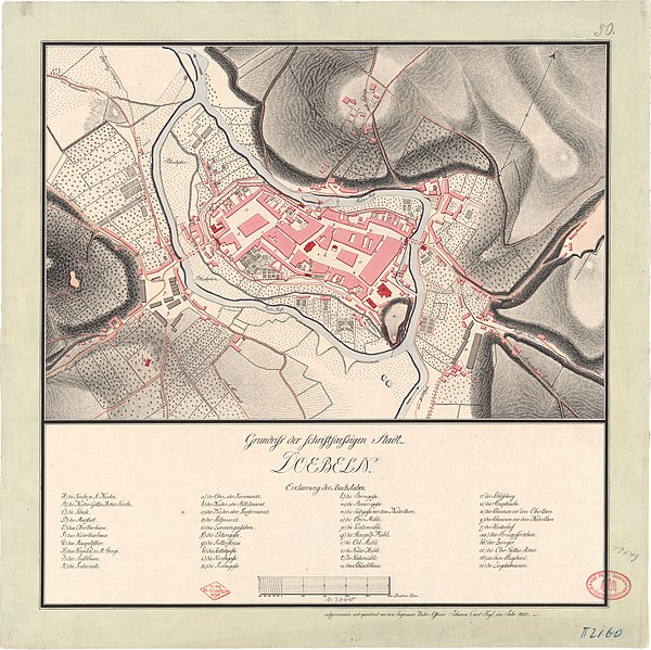
| Title |
Grundriß der schriftsaeßigen Stadt DOEBELN. |
| Description |
Deutsch: Stadtplan von Döbeln (Sächsische Landesaufnahme von 1780 bis 1825); Stempel: K: PR: PLANKAMMER 1816. und Königl. Pr. Gr. Generalstab Karten-Archiv |
| Map legend |
[im Original:] Erklaerung der Buchstaben.
|
| Date | |
| Source | Deutsche Fotothek (id: df_dk_0001200) |
| Creator |
Johann Carl Heyl |
| Geotemporal data | |
| Map location | Döbeln |
| Scale | ca. 1 : 3000 |
| Heading |
 |
| Georeferencing | If inappropriate please set warp_status = skip to hide. |
| Bibliographic data | |
| Language | German |
| Archival data | |
| Dimensions | height: 33 cm (12.9 in); width: 50 cm (19.6 in) |
| Medium | drawing |
Licensing
[edit]
|
This work is in the public domain in its country of origin and other countries and areas where the copyright term is the author's life plus 100 years or fewer. This work is in the public domain in the United States because it was published (or registered with the U.S. Copyright Office) before January 1, 1929. | |
| This file has been identified as being free of known restrictions under copyright law, including all related and neighboring rights. | |
File history
Click on a date/time to view the file as it appeared at that time.
| Date/Time | Thumbnail | Dimensions | User | Comment | |
|---|---|---|---|---|---|
| current | 22:42, 13 January 2021 | | 7,660 × 7,650 (14.8 MB) | Mapmarks (talk | contribs) | == {{int:filedesc}} == {{map |title=''Grundriß der schriftsaeßigen Stadt DOEBELN.'' |description={{de|1=Stadtplan von Döbeln (Sächsische Landesaufnahme von 1780 bis 1825); Stempel: ''K: PR: PLANKAMMER 1816.'' und ''Königl. Pr. Gr. Generalstab Karten-Archiv''}} |legend=[im Original:] ''Erklaerung der Buchstaben.'' * ''A.) die Kirche zu St: Nicolai.'' * ''B.) die Nieder-Gottes-Acker Kirche.'' * ''C.) die Schule.'' * ''D.) der Marstall.'' * ''E.) das Oberthorhaus.'' * ''F.) das Niederthorhaus.''... |
You cannot overwrite this file.
File usage on Commons
The following 3 pages use this file:
File usage on other wikis
The following other wikis use this file:
- Usage on de.wikipedia.org