File:Grottes d'Arcy--Cassini.png
Jump to navigation
Jump to search

Size of this preview: 800 × 386 pixels. Other resolutions: 320 × 154 pixels | 640 × 309 pixels | 1,098 × 530 pixels.
Original file (1,098 × 530 pixels, file size: 1.02 MB, MIME type: image/png)
Captions
Captions
Add a one-line explanation of what this file represents
Summary
[edit]
| Description |
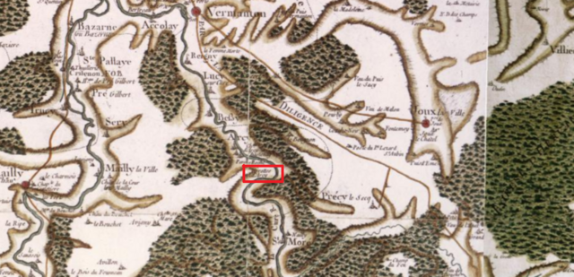
English: Cassini map (18th century - published around 1766-1768), detail. Centered on the prehistoric site of Arcy-sur-Cure caves (red rectangle), about 30 km south of Auxerre, in the present Yonne departement, in Burgundy, France.
The site borders the Cure river that flows south-north, cutting through the middle of the map.
Français : Carte de Cassini (XVIIIe s. - publié vers 1766-1768), détail. Centré sur le site préhistorique des grottes d'Arcy-sur-Cure (rectangle rouge), à environ 30 km au sud d'Auxerre, département de l'Yonne, Bourgogne, France. Le site est en rive gauche de la Cure, qui traverse la carte du sud au nord. Elle rejoint la rivière Yonne près du bord supérieur de la carte. La "route de [Paris à] Lyon par la diligence" passe en parallèle à la Cure, à l'est de la rivière ; une branche part de Vermenton pour desservir Joux-la-Ville. Parmi les nombreux villages, bourgs et villes on compte Vermenton, Lucy sur Cure, Bessy, Saint-Moré, Joux-la-Ville, Précy le Secq, Mailly la Ville, Mailly le Château, Sery, Trucy, Prégilbert, Sainte-Pallaye, Accolay. Elle montre aussi des lieux comme les rochers du Saussois, la grotte de Pêche-Roche (entre les grottes d'Arcy et le village d'Arcy), ou l'abbaye de Crisenon. |
| Date | |
| Source | Own work |
| Author | Pueblopassingby |
| Camera location | | View this and other nearby images on: OpenStreetMap |
|---|
Licensing
[edit]
|
This work is in the public domain in its country of origin and other countries and areas where the copyright term is the author's life plus 70 years or fewer. | |
| This file has been identified as being free of known restrictions under copyright law, including all related and neighboring rights. | |
File history
Click on a date/time to view the file as it appeared at that time.
| Date/Time | Thumbnail | Dimensions | User | Comment | |
|---|---|---|---|---|---|
| current | 23:31, 14 September 2018 | | 1,098 × 530 (1.02 MB) | Pueblo89 (talk | contribs) | User created page with UploadWizard |
You cannot overwrite this file.
File usage on Commons
The following 2 pages use this file:
File usage on other wikis
The following other wikis use this file:
- Usage on fr.wikipedia.org