File:Grosvenor Bridge and Chester Skyline - geograph.org.uk - 298495.jpg
Jump to navigation
Jump to search
No higher resolution available.
Grosvenor_Bridge_and_Chester_Skyline_-_geograph.org.uk_-_298495.jpg (640 × 458 pixels, file size: 39 KB, MIME type: image/jpeg)
Captions
Captions
Add a one-line explanation of what this file represents
Summary
[edit]
| Description |
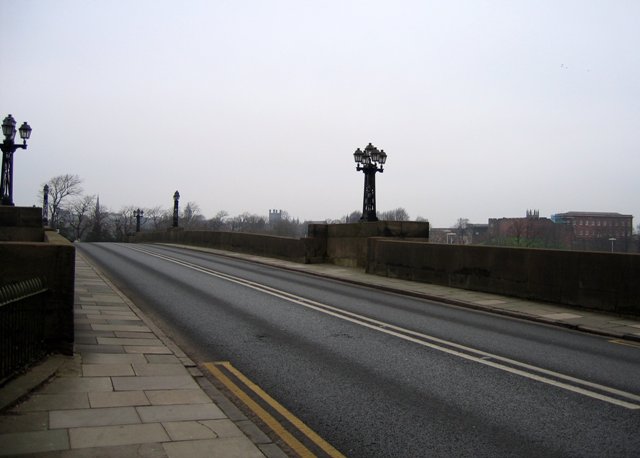
English: Grosvenor Bridge and Chester Skyline Taken from the top of the angled footpath that runs from the Grosvenor Bridge pavement down to the Dingle. From left to right, the spire lined up with the centre of the road is the Guild Hall at the junction of Watergate St and Nicholas St, the pointed tower just to the right of the bridge lamp is the Town Hall, next the square tower with the four little towers is the Cathedral, and on the right the array of little spires behind the old castle wall is the top of St Mary's Centre, formerly St Mary's on the Hill. The large building on the right is part of the Chester Castle complex. Who knows how this skyline may change in the future? |
| Date | |
| Source | From geograph.org.uk |
| Author | John S Turner |
| Attribution (required by the license) | John S Turner / Grosvenor Bridge and Chester Skyline / |
| Camera location | | View this and other nearby images on: OpenStreetMap |
|---|
_heading:22.00&language=en)
| Object location | | View this and other nearby images on: OpenStreetMap |
|---|
_heading:22.00&language=en)
Licensing
[edit]

|
This image was taken from the Geograph project collection. See this photograph's page on the Geograph website for the photographer's contact details. The copyright on this image is owned by John S Turner and is licensed for reuse under the Creative Commons Attribution-ShareAlike 2.0 license.
|
This file is licensed under the Creative Commons Attribution-Share Alike 2.0 Generic license.
Attribution: John S Turner
- You are free:
- to share – to copy, distribute and transmit the work
- to remix – to adapt the work
- Under the following conditions:
- attribution – You must give appropriate credit, provide a link to the license, and indicate if changes were made. You may do so in any reasonable manner, but not in any way that suggests the licensor endorses you or your use.
- share alike – If you remix, transform, or build upon the material, you must distribute your contributions under the same or compatible license as the original.
- Remove redundant categories and try to put this image in the most specific category/categories
- Remove this template
- The location categories are based on information from this geonames tool and this OpenStreetMap tool combined with a database. You can also have a look at this tool from mysociety.
- The topic category from Geograph was Christmas Day 2006 (find similar images Day 2006 at Geograph)
File history
Click on a date/time to view the file as it appeared at that time.
| Date/Time | Thumbnail | Dimensions | User | Comment | |
|---|---|---|---|---|---|
| current | 21:19, 14 December 2010 | | 640 × 458 (39 KB) | GeographBot (talk | contribs) | == {{int:filedesc}} == {{Information |description={{en|1=Grosvenor Bridge and Chester Skyline Taken from the top of the angled footpath that runs from the Grosvenor Bridge pavement down to the Dingle. From left to right, the spire lined up with the centre |
You cannot overwrite this file.
File usage on Commons
There are no pages that use this file.