File:Grenzverlauf A-SLW.png
Jump to navigation
Jump to search

Size of this preview: 800 × 402 pixels. Other resolutions: 320 × 161 pixels | 640 × 321 pixels | 1,024 × 514 pixels | 1,280 × 643 pixels | 2,706 × 1,359 pixels.
Original file (2,706 × 1,359 pixels, file size: 5.47 MB, MIME type: image/png)
Captions
Captions
Add a one-line explanation of what this file represents
Summary
[edit]| Description |
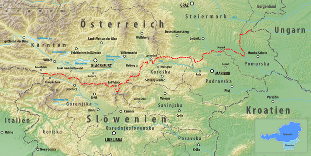
Deutsch: Reliefkarte des Grenzverlaufes zwischen Österreich und Slowenien
Topographischer Hintergrund: NASA Shuttle Radar Topography Mission (public domain). SRTM3 v.2. |
||||||||
| Date | |||||||||
| Source | Own work | ||||||||
| Author | Tschubby | ||||||||
| Permission (Reusing this file) |
I, the copyright holder of this work, hereby publish it under the following licenses:
This file is licensed under the Creative Commons Attribution-Share Alike 2.5 Generic, 2.0 Generic and 1.0 Generic license.
You may select the license of your choice. |

File history
Click on a date/time to view the file as it appeared at that time.
| Date/Time | Thumbnail | Dimensions | User | Comment | |
|---|---|---|---|---|---|
| current | 12:44, 11 September 2024 | | 2,706 × 1,359 (5.47 MB) | Tschubby (talk | contribs) | == {{int:filedesc}} == {{Information |Description= {{de| Reliefkarte des Grenzverlaufes zwischen Italien und Slowenien}} Topographischer Hintergrund: [http://www2.jpl.nasa.gov/srtm NASA Shuttle Radar Topography Mission] (public domain). SRTM3 v.2. |Source={{own}} |Date= 2020-02-08 |Author= Tschubby |Permission= {{self|GFDL|Cc-by-sa-3.0-migrated|Cc-by-sa-2.5,2.0,1.0}} |other_versions= }} Category:Borders of Italy-Slovenia |
| 12:14, 12 February 2019 |  | 2,706 × 1,359 (5.69 MB) | Tschubby (talk | contribs) | {{Information |description= |date= |source= |author= |permission= |other versions= }} | |
| 18:17, 9 February 2019 |  | 2,706 × 1,359 (5.85 MB) | Tschubby (talk | contribs) | {{Information |Description= {{de| Reliefkarte des Grenzverlaufes zwischen Österreich und Slowenien}} Topographischer Hintergrund: [http://www2.jpl.nasa.gov/srtm NASA Shuttle Radar Topography Mission] (public domain). SRTM3 v.2. |Source={{own}} |Date= 2019-02-09 |Author= Tschubby |Permission= {{self|GFDL|Cc-by-sa-3.0-migrated|Cc-by-sa-2.5,2.0,1.0}} |other_versions= }} Category:Borders of Austria-Slovenia |
You cannot overwrite this file.
File usage on Commons
There are no pages that use this file.
File usage on other wikis
The following other wikis use this file:
- Usage on de.wikipedia.org
- Usage on es.wikipedia.org
- Usage on pl.wikipedia.org
- Usage on pt.wikipedia.org