File:Grenland CIA map SZL.png
Jump to navigation
Jump to search

Size of this preview: 279 × 600 pixels. Other resolutions: 111 × 240 pixels | 329 × 707 pixels.
Original file (329 × 707 pixels, file size: 47 KB, MIME type: image/png)
Captions
Captions
Add a one-line explanation of what this file represents
Summary
[edit]
| Description |
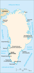
Ślůnski: Karta Grynlandyje z "CIA-The World Factbook" po ślōnsku. |
| Date | |
| Source | CIA World Factbook - modified to Silesian language |
| Author | Central Intelligence Agency |
Licensing
[edit]
This image is in the public domain because it contains materials that originally came from the United States Central Intelligence Agency's World Factbook.
|
 |
File history
Click on a date/time to view the file as it appeared at that time.
| Date/Time | Thumbnail | Dimensions | User | Comment | |
|---|---|---|---|---|---|
| current | 07:07, 23 February 2021 | | 329 × 707 (47 KB) | Psiŏczek (talk | contribs) | Uploaded a work by Central Intelligence Agency from CIA World Factbook - modified to Silesian language with UploadWizard |
You cannot overwrite this file.
File usage on Commons
The following page uses this file:
File usage on other wikis
The following other wikis use this file:
- Usage on szl.wikipedia.org