File:Greenock Blitz damage.jpg
Jump to navigation
Jump to search
Size of this preview: 800 × 398 pixels. Other resolutions: 320 × 159 pixels | 640 × 319 pixels | 1,143 × 569 pixels.
Original file (1,143 × 569 pixels, file size: 176 KB, MIME type: image/jpeg)
Captions
Captions
Add a one-line explanation of what this file represents
Summary
[edit]
| Description |
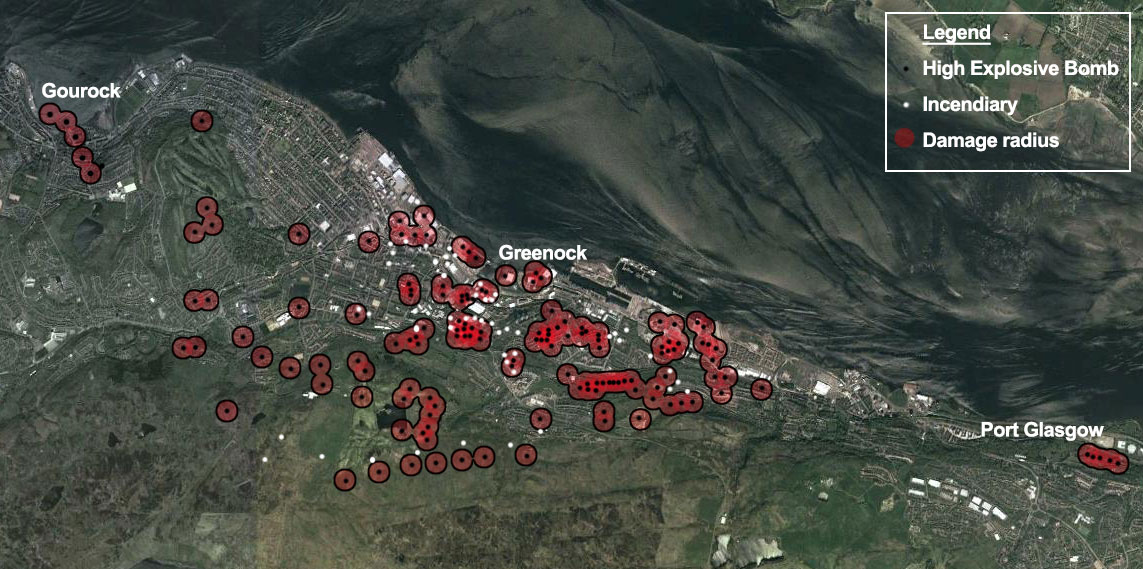
English: This map, showing GIS data overlaid an aerial map, shows the locations of bombs dropped on the Port Glasgow, Greenock, and Gourock areas during the nights of 6-7 May 1941. |
| Date | |
| Source |
Grant McLachlan collected the information and created the map |
| Author | GrantMcLMcLachlan |
Licensing
[edit]
I, the copyright holder of this work, hereby publish it under the following licenses:

|
Permission is granted to copy, distribute and/or modify this document under the terms of the GNU Free Documentation License, Version 1.2 or any later version published by the Free Software Foundation; with no Invariant Sections, no Front-Cover Texts, and no Back-Cover Texts. A copy of the license is included in the section entitled GNU Free Documentation License. |
This file is licensed under the Creative Commons Attribution-Share Alike 3.0 Unported license.
- You are free:
- to share – to copy, distribute and transmit the work
- to remix – to adapt the work
- Under the following conditions:
- attribution – You must give appropriate credit, provide a link to the license, and indicate if changes were made. You may do so in any reasonable manner, but not in any way that suggests the licensor endorses you or your use.
- share alike – If you remix, transform, or build upon the material, you must distribute your contributions under the same or compatible license as the original.
You may select the license of your choice.
File history
Click on a date/time to view the file as it appeared at that time.
| Date/Time | Thumbnail | Dimensions | User | Comment | |
|---|---|---|---|---|---|
| current | 14:30, 12 July 2013 | | 1,143 × 569 (176 KB) | GrantMcLMcLachlan (talk | contribs) | {{subst:Upload marker added by en.wp UW}} {{Information |Description = {{en|This map, showing GIS data overlaid an aerial map, shows the locations of bombs dropped on the Port Glasgow, Greenock, and Gourock areas during the nights of 6-7 May 1941.}} |S... |
You cannot overwrite this file.
File usage on Commons
There are no pages that use this file.