File:Greenland Ice Sheet and Summit Station (3790163242).jpg
Greenland_Ice_Sheet_and_Summit_Station_(3790163242).jpg (500 × 306 pixels, file size: 75 KB, MIME type: image/jpeg)
Captions
Captions
Summary
[edit].jpg&action=edit§ion=1)
| Description |
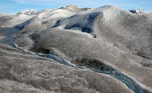
A stream of runoff from the Greenland ice sheet begins its journey to the ocean. This area of Greenland is home to Summit Station, an NSF-supported research station located atop 3,200 meters (10,000 feet) of ice (and nearly 400 kilometers from the nearest point of land) at the peak of the Greenland ice sheet. Summit Station is the home of the Greenland Environmental Observatory (GEOSummit), which conducts year-round climate monitoring of key climate variables--conducted to study air-snow interactions--the knowledge of which is crucial for interpreting data from ice cores drilled in the area and elsewhere. This image is one of a series on Summit Station in the NSF Multimedia Gallery. Credit: Peter West, National Science Foundation |
| Date | |
| Source | Greenland Ice Sheet and Summit Station |
| Author | National Science Foundation |
Licensing
[edit].jpg&action=edit§ion=2)
| This image is a work of a National Science Foundation employee, taken or made as part of that person's official duties. As a work of the U.S. federal government, the image is in the public domain. |  |
| This image was originally posted to Flickr by National Science Foundation at https://flickr.com/photos/37157086@N02/3790163242. It was reviewed on 19 January 2018 by FlickreviewR 2 and was confirmed to be licensed under the terms of the United States Government Work. |
File history
Click on a date/time to view the file as it appeared at that time.
| Date/Time | Thumbnail | Dimensions | User | Comment | |
|---|---|---|---|---|---|
| current | 14:02, 19 January 2018 | | 500 × 306 (75 KB) | Artix Kreiger 2 (talk | contribs) | Transferred from Flickr via Flickr2Commons |
You cannot overwrite this file.
File usage on Commons
There are no pages that use this file.
.jpg&oldid=810489900)