File:GreciaEnEntreguerras.svg
Jump to navigation
Jump to search

Size of this PNG preview of this SVG file: 608 × 599 pixels. Other resolutions: 243 × 240 pixels | 487 × 480 pixels | 779 × 768 pixels | 1,039 × 1,024 pixels | 2,078 × 2,048 pixels | 2,029 × 2,000 pixels.
Original file (SVG file, nominally 2,029 × 2,000 pixels, file size: 420 KB)
Captions
Captions
Add a one-line explanation of what this file represents
Summary
[edit]
| Description |
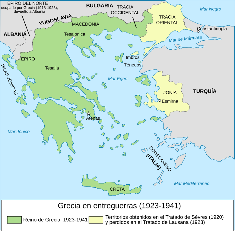
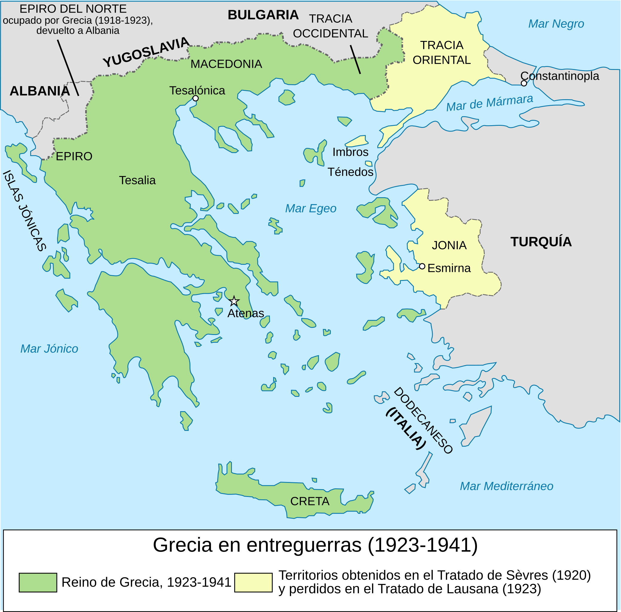
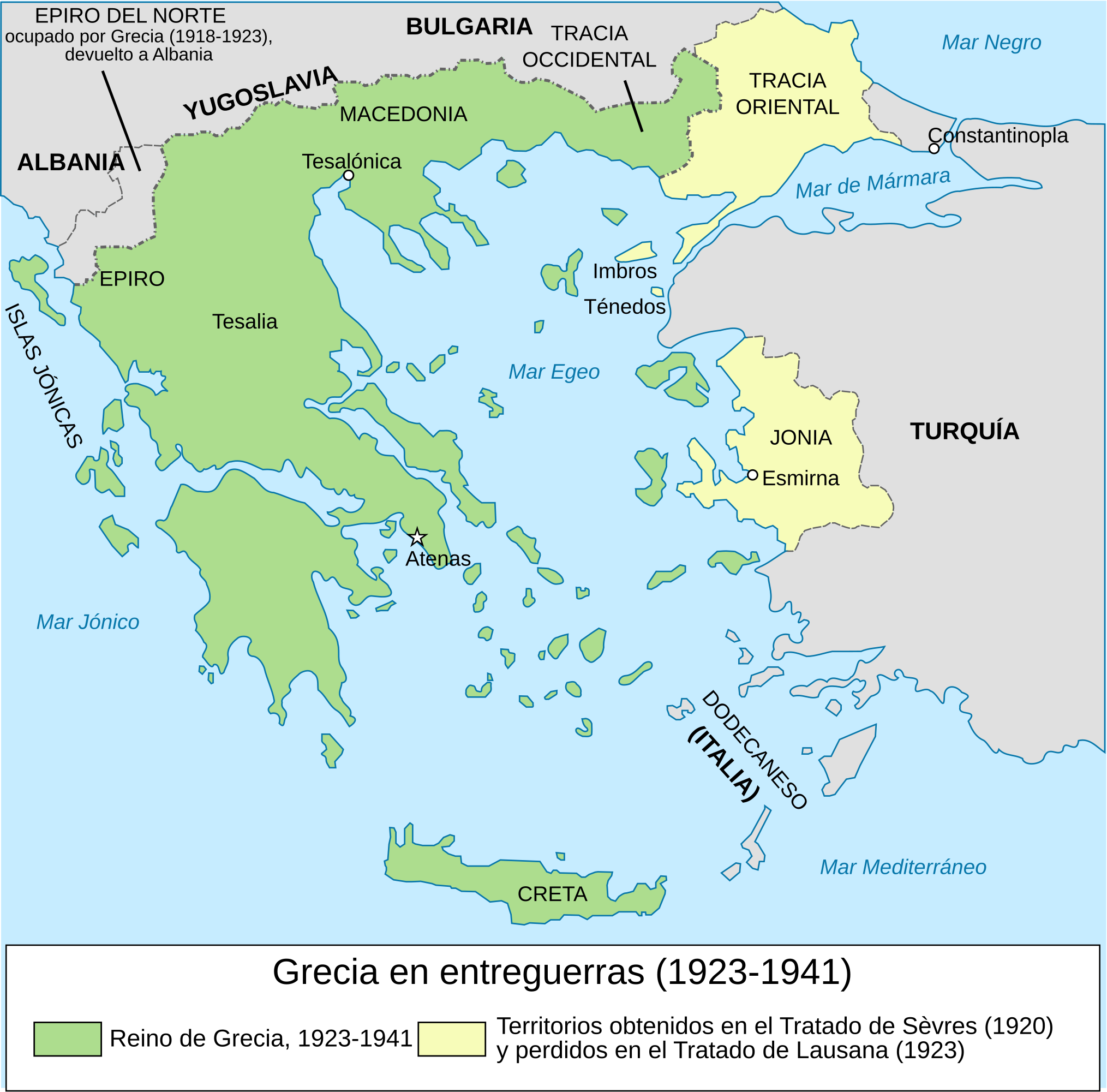
Español: Grecia durante el periodo de entreguerras, 1923-1941. |
| Date | (UTC) |
| Source |
This file was derived from: Map Greece expansion 1832-1947-es.svg:  |
| Author |
|
| This is a retouched picture, which means that it has been digitally altered from its original version. Modifications: Used for the interwar period. The original can be viewed here: Map Greece expansion 1832-1947-es.svg:
|
Licensing
[edit]
This file is licensed under the Creative Commons Attribution-Share Alike 3.0 Unported license.
- You are free:
- to share – to copy, distribute and transmit the work
- to remix – to adapt the work
- Under the following conditions:
- attribution – You must give appropriate credit, provide a link to the license, and indicate if changes were made. You may do so in any reasonable manner, but not in any way that suggests the licensor endorses you or your use.
- share alike – If you remix, transform, or build upon the material, you must distribute your contributions under the same or compatible license as the original.
Original upload log
[edit]
This image is a derivative work of the following images:
- File:Map_Greece_expansion_1832-1947-es.svg licensed with Cc-by-sa-3.0-migrated, GFDL
- 2007-12-28T20:06:22Z Reignerok 734x962 (112742 Bytes) {{Information |Description= {{es|Expansión territorial de Grecia, 1832-1947.}} |Source=Image:Map Greece expansion 1832-1947-fr.svg (adaptation of [[:Image:Population exchange 1923.gif]], GFDL). Image renamed from [[:Image:L'
Uploaded with derivativeFX
File history
Click on a date/time to view the file as it appeared at that time.
| Date/Time | Thumbnail | Dimensions | User | Comment | |
|---|---|---|---|---|---|
| current | 17:19, 15 January 2020 | | 2,029 × 2,000 (420 KB) | Rowanwindwhistler (talk | contribs) | Typo corrected |
| 07:27, 22 July 2017 |  | 2,029 × 2,000 (546 KB) | Rowanwindwhistler (talk | contribs) | Fake text added, larger, new colours... | |
| 08:42, 19 August 2012 |  | 733 × 723 (95 KB) | Rowanwindwhistler (talk | contribs) | == {{int:filedesc}} == {{Information |Description={{es|1=Grecia durante el periodo de entreguerras, 1923-1941.}} |Source={{Derived from|Map_Greece_expansion_1832-1947-es.svg|display=50}} |Date=2012-08-19 08:41 (UTC) |Author=*[[:File:Map_Greece_expansio... |
You cannot overwrite this file.
File usage on Commons
There are no pages that use this file.
File usage on other wikis
The following other wikis use this file:
- Usage on es.wikipedia.org