File:Greater Bashkiria in 1922.svg
Jump to navigation
Jump to search

Size of this PNG preview of this SVG file: 670 × 600 pixels. Other resolutions: 268 × 240 pixels | 536 × 480 pixels | 858 × 768 pixels | 1,144 × 1,024 pixels | 2,287 × 2,048 pixels | 879 × 787 pixels.
Original file (SVG file, nominally 879 × 787 pixels, file size: 2.16 MB)
Captions
Captions
Add a one-line explanation of what this file represents
Summary
[edit]
| Description |
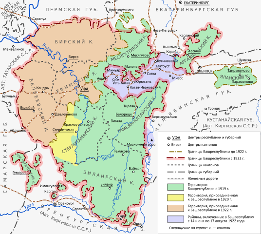
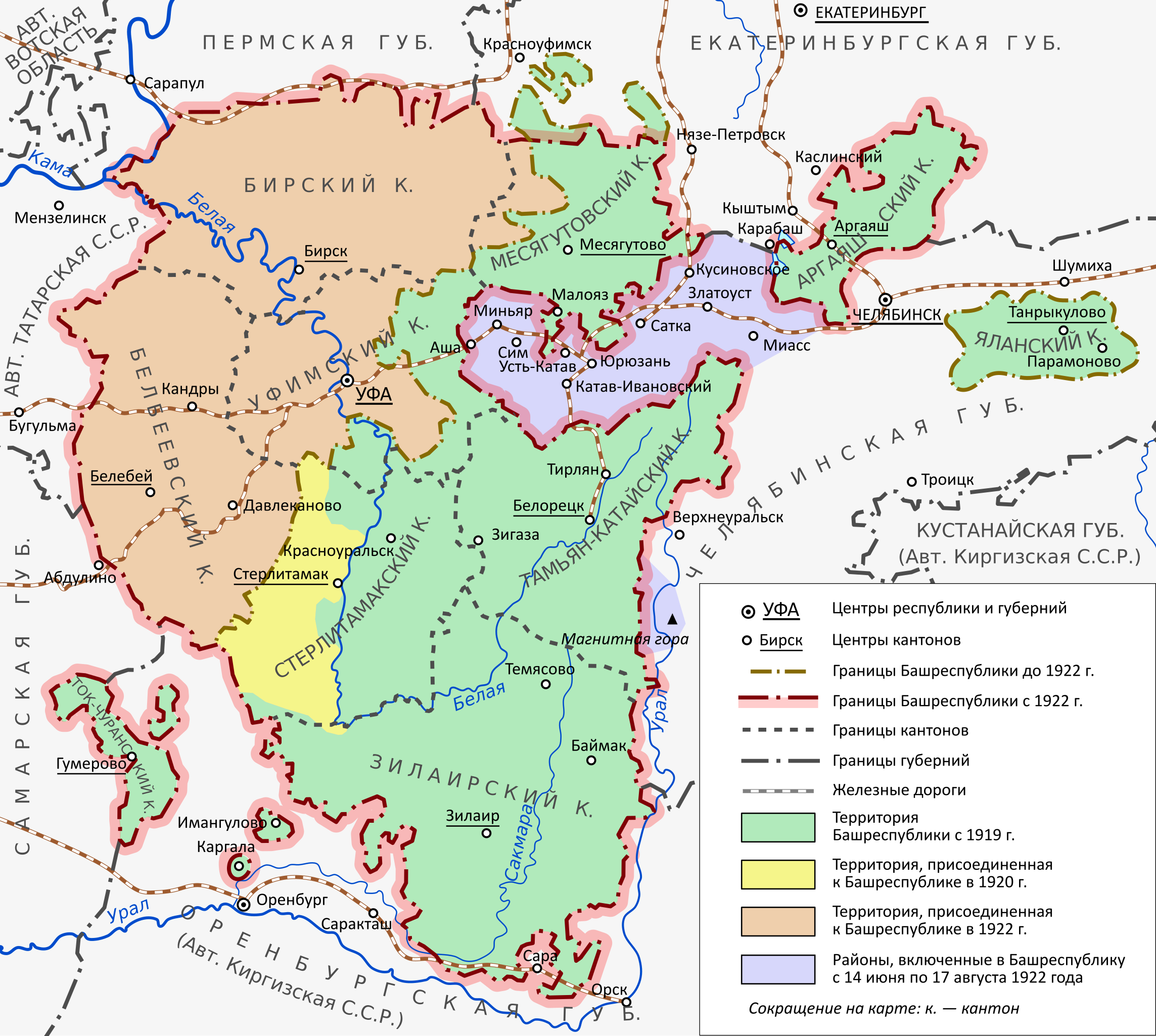
English: Map of the territorial changes of the Bashkir Republic in 1920-1922. |
| Date | |
| Source | Own work |
| Author | Hellerick |
Licensing
[edit]
I, the copyright holder of this work, hereby publish it under the following license:
This file is licensed under the Creative Commons Attribution-Share Alike 4.0 International license.
- You are free:
- to share – to copy, distribute and transmit the work
- to remix – to adapt the work
- Under the following conditions:
- attribution – You must give appropriate credit, provide a link to the license, and indicate if changes were made. You may do so in any reasonable manner, but not in any way that suggests the licensor endorses you or your use.
- share alike – If you remix, transform, or build upon the material, you must distribute your contributions under the same or compatible license as the original.
File history
Click on a date/time to view the file as it appeared at that time.
| Date/Time | Thumbnail | Dimensions | User | Comment | |
|---|---|---|---|---|---|
| current | 16:28, 26 May 2018 | | 879 × 787 (2.16 MB) | Hellerick (talk | contribs) | + Yekaterinburg; + Krasnoufimsk; governorate cities marked as such; the name Maloyaz was missing. |
| 17:23, 25 November 2017 |  | 879 × 787 (2.09 MB) | Hellerick (talk | contribs) | Matching railroad color with the legend. | |
| 17:20, 25 November 2017 |  | 879 × 787 (2.09 MB) | Hellerick (talk | contribs) | Votyak Autonomous Oblast; Orenburg Governorate to Kirghiz ASSR. | |
| 16:21, 25 November 2017 |  | 879 × 787 (2.07 MB) | Hellerick (talk | contribs) | Matching railroad color with the legend. | |
| 15:45, 25 November 2017 |  | 879 × 787 (2.07 MB) | Hellerick (talk | contribs) | Renaming Tatarstan again; + Kustanay Governorate. | |
| 15:02, 23 November 2017 |  | 879 × 787 (2.04 MB) | Hellerick (talk | contribs) | Matching railroad color with the legend. | |
| 14:47, 23 November 2017 |  | 879 × 787 (2.04 MB) | Hellerick (talk | contribs) | Fixing southern enclaves borders. | |
| 09:52, 23 November 2017 |  | 879 × 787 (2.03 MB) | Hellerick (talk | contribs) | Tatarstan renamed again | |
| 03:46, 22 November 2017 |  | 879 × 787 (2.02 MB) | Hellerick (talk | contribs) | Fixing typo, borders, position of Magnitnaya Gora. | |
| 12:50, 21 November 2017 |  | 879 × 787 (3.17 MB) | Hellerick (talk | contribs) | Changed southern borders; renamed Tatarstan |
You cannot overwrite this file.
File usage on Commons
The following 2 pages use this file:
File usage on other wikis
The following other wikis use this file:
- Usage on ba.wikipedia.org
- Usage on de.wikipedia.org
- Usage on en.wikipedia.org
- Usage on kk.wikipedia.org
- Usage on ru.wikipedia.org
- Башкирская Автономная Советская Социалистическая Республика
- Малая Башкирия
- Танрыкулово
- История административно-территориального деления Башкортостана
- Башкортостан в годы Гражданской войны
- Обсуждение участника:Ryanag/Архив/3
- Обсуждение участника:Luterr/Архив/2017
- Проект:Графическая мастерская/Заявки/Архив/2017/11
- Парамоново (Курганская область)
- Википедия:Форум/Архив/Общий/2018/08
- Участник:Ryanag/Черновик
- Проект:Графическая мастерская/Заявки/Архив/2019/08
- Usage on tr.wikipedia.org
- Usage on tt.wikipedia.org
- Usage on uk.wikipedia.org
- Usage on zh.wikipedia.org