File:Great Haywood Trent Lane geograph-3891208-by-Ben-Brooksbank.jpg
Jump to navigation
Jump to search

Size of this preview: 800 × 462 pixels. Other resolutions: 320 × 185 pixels | 640 × 370 pixels | 1,024 × 591 pixels | 1,280 × 739 pixels | 2,346 × 1,355 pixels.
Original file (2,346 × 1,355 pixels, file size: 3.4 MB, MIME type: image/jpeg)
Captions
Captions
Add a one-line explanation of what this file represents
Summary
[edit]
| Description |
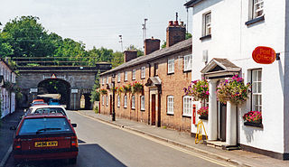
English: Bridges along Trent Lane, Great Haywood 1995. View southward to the railway over-bridge, then to the bridge of the Trent & Mersey Canal. Just to the right used to be Great Haywood Halt (closed 6/1/47 after having latterly only one train a day calling). This is the ex-North Stafford Colwich - Stone line, electrified 1965, which is followed by main line trains from Euston to Manchester via Stoke-on-Trent. |
| Date | |
| Source | From geograph.org.uk |
| Author | Ben Brooksbank |
| Permission (Reusing this file) |
Creative Commons Attribution Share-alike license 2.0 |
| Attribution (required by the license) | Ben Brooksbank / Bridges along Trent Lane, Great Haywood 1995 / |
| Camera location | | View this and other nearby images on: OpenStreetMap |
|---|
Licensing
[edit]

|
This image was taken from the Geograph project collection. See this photograph's page on the Geograph website for the photographer's contact details. The copyright on this image is owned by Ben Brooksbank and is licensed for reuse under the Creative Commons Attribution-ShareAlike 2.0 license.
|
This file is licensed under the Creative Commons Attribution-Share Alike 2.0 Generic license.
Attribution: Ben Brooksbank
- You are free:
- to share – to copy, distribute and transmit the work
- to remix – to adapt the work
- Under the following conditions:
- attribution – You must give appropriate credit, provide a link to the license, and indicate if changes were made. You may do so in any reasonable manner, but not in any way that suggests the licensor endorses you or your use.
- share alike – If you remix, transform, or build upon the material, you must distribute your contributions under the same or compatible license as the original.
File history
Click on a date/time to view the file as it appeared at that time.
| Date/Time | Thumbnail | Dimensions | User | Comment | |
|---|---|---|---|---|---|
| current | 06:10, 18 April 2014 | | 2,346 × 1,355 (3.4 MB) | Chevin (talk | contribs) | == {{int:filedesc}} == {{Information |Description={{en|1='''Bridges along Trent Lane, Great Haywood 1995.'''<br/> View southward to the railway over-bridge, then to the bridge of the Trent & Mersey Canal. Just to the right used to be Great Haywood Halt... |
You cannot overwrite this file.
File usage on Commons
There are no pages that use this file.
File usage on other wikis
The following other wikis use this file:
- Usage on en.wikipedia.org