File:Graphical, Statistical, and Historical Map of Mississippi by Carey and Lea, 1822.jpg

Original file (2,048 × 1,614 pixels, file size: 949 KB, MIME type: image/jpeg)
Captions
Captions
Summary
[edit]
| Description |
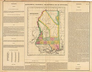
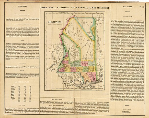
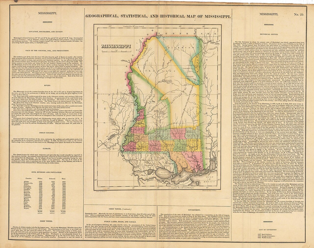
English: Antique Map of the state of Mississippi from 1822
By: Henry Charles Carey and Isaac Lea Date: 1822 (published) Philadelphia Dimensions: 22.25 x 17.5 inches (56.5 x 44.4 centimeters) This map was published in Philadelphia in Henry Carey and Isaac Lea’s “Complete Historical, Chronological and Geographical American Atlas” in 1822. Many of the original map drawings were drawn by Fielding Lucas, one of the earliest successful map-publishers in Baltimore. This antique piece of Americana displays the state of Mississippi as it was in 1822. The map is divided into many different fragments, showing the Choctaws and Chickasaw possessions to the north. Just two years before the publishing of the map, the land marked Hinds was ceded to the United States, and was yet to be annexed (marked in green). Another item worthy of note is “General Jackson’s Road from New Orleans to the Muscle Shoals”, it was used by General Jackson during the war of 1812 to reach New Orleans quickly and win the legendary Battle of New Orleans, the victory that catapulted him into the Presidency. Surrounding the map are many different details about the state of Mississippi as it was in 1821. Topographical, historical, and statistical data line the sides, with thorough census data. A state in transition, this historic map captures the evolution of the Magnolia State to the fullest. |
| Date | |
| Source | https://nwcartographic.com/products/1822-graphical-statistical-and-historical-map-of-mississippi |
| Author | New World Cartographic |
Licensing
[edit]
- You are free:
- to share – to copy, distribute and transmit the work
- to remix – to adapt the work
- Under the following conditions:
- attribution – You must give appropriate credit, provide a link to the license, and indicate if changes were made. You may do so in any reasonable manner, but not in any way that suggests the licensor endorses you or your use.
- share alike – If you remix, transform, or build upon the material, you must distribute your contributions under the same or compatible license as the original.
File history
Click on a date/time to view the file as it appeared at that time.
| Date/Time | Thumbnail | Dimensions | User | Comment | |
|---|---|---|---|---|---|
| current | 17:56, 1 July 2020 | | 2,048 × 1,614 (949 KB) | New World Cartographic (talk | contribs) | Cross-wiki upload from commons.wikimedia.org |
You cannot overwrite this file.
File usage on Commons
There are no pages that use this file.