File:Grange Bateliere & Porcherons (Dheulland).jpg
Jump to navigation
Jump to search
Size of this preview: 800 × 462 pixels. Other resolutions: 320 × 185 pixels | 640 × 369 pixels | 1,024 × 591 pixels | 1,478 × 853 pixels.
Original file (1,478 × 853 pixels, file size: 516 KB, MIME type: image/jpeg)
Captions
Captions
Add a one-line explanation of what this file represents
Summary
[edit].jpg&action=edit§ion=1)
| Description |
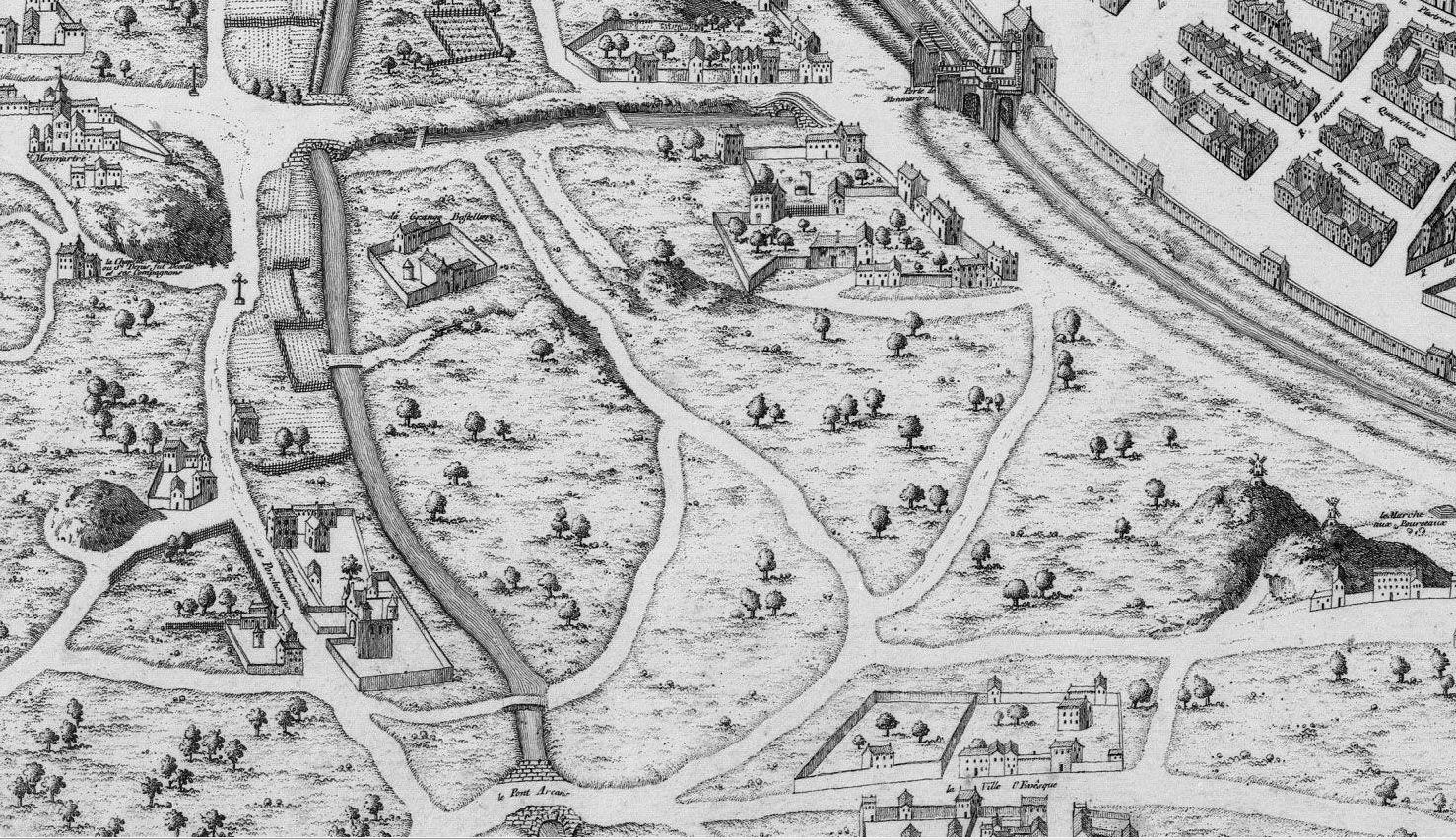
English: North-west corner (left bottom) on the map of Dheulland (1552) with the fr:porte Montmartre, fr:Ferme de la Grange-Batelière, the fr:Château des Porcherons and Arcans bridge over the ruisseau de Ménilmontant - Grand Égout between them. We see also the chapelle des Martyrs and the church en:Saint-Pierre de Montmartre. The scale is deformed in order to put them on the plan, because they are more in the north (on the left).
Français : Coin nord ouest (en bas à gauche) du plan de Dheulland (1552) avec la fr:porte Montmartre, la fr:Ferme de la Grange-Batelière, le fr:Château des Porcherons et le pont d'Arcans sur le ruisseau de Ménilmontant - Grand Égout qui coule entre les deux. On voit aussi la chapelle des Martyrs et l'fr:Église Saint-Pierre de Montmartre. L'échelle est déformée pour les faire entrer dans le plan, car ils sont en réalité beaucoup plus au nord (=à gauche). |
||||
| Date | |||||
| Source |
This file was derived from: Plan de Saint-Victor vers 1550, d'après la reprise de Dheulland en 1756 - aviary.jpg |
||||
| Author | Tangopaso | ||||
| Permission (Reusing this file) |
|
||||
| Other versions |
 |
||||
Licensing
[edit].jpg&action=edit§ion=2)
| I, the copyright holder of this work, release this work into the public domain. This applies worldwide. In some countries this may not be legally possible; if so: I grant anyone the right to use this work for any purpose, without any conditions, unless such conditions are required by law. |
| Annotations | This image is annotated: View the annotations at Commons |
.jpg)
File history
Click on a date/time to view the file as it appeared at that time.
| Date/Time | Thumbnail | Dimensions | User | Comment | |
|---|---|---|---|---|---|
| current | 20:51, 2 February 2014 | | 1,478 × 853 (516 KB) | Tangopaso (talk | contribs) | == {{int:filedesc}} == {{Information |Description= !!!{{en|1=North-west corner (left bottom) on the map of Dheulland (1552) with the fr:porte Montmartre, fr:Ferme de la Grange-Batelière, the fr:Château des Porcherons and Arcans bridge... |
You cannot overwrite this file.
File usage on Commons
There are no pages that use this file.
File usage on other wikis
The following other wikis use this file:
- Usage on fr.wikipedia.org
Metadata
.jpg&oldid=851988843)
Categories:
- Plan de Dheulland - derivatives files
- Ruisseau de Ménilmontant
- Grange Bateliere farm
- Château des Porcherons
- Chapelle du Sanctum Martyrium (Paris)
- Historical images of Église Saint-Pierre de Montmartre
- Old submaps of Paris 9e arrondissement
- Butte des Moulins
- Churches in Paris on the maps
- Ville l'Évêque (Paris)