File:Grand Canyon National Park, North Kaibab Trail in Redwall 1017 - Flickr - Grand Canyon NPS.jpg

Original file (4,733 × 4,348 pixels, file size: 5.97 MB, MIME type: image/jpeg)
Captions
Captions
Summary
[edit]
| Description |
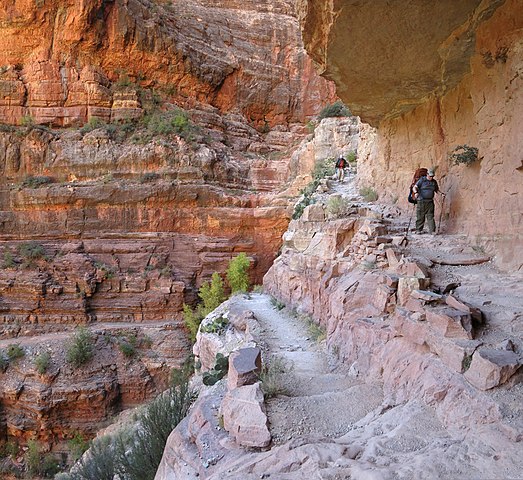
Below Supai Tunnel, switchbacks continue to the massive cliffs of Redwall Limestone, (about 3.5 miles/5.6 km) where for long stretches the trail has been blasted out of the cliff in a half tunnel. The Redwall section is awe-inspiring in every way; fantastic exposure and views mingle with a reminiscence of an age when engineering marvels were commonplace. A hike to Roaring Springs and back is extremely strenuous and takes a full day (7-8 hours) - begin your hike before 7 a.m. Roaring Springs lies 3,050 feet / 930 m below the canyon rim and is 9.4 miles / 15 km round-trip. A day hike beyond Roaring Springs is not recommended. Many years of experience have shown that hikers who proceed beyond this point during the hottest parts of the day have a much greater probability of suffering from heat-related illness, injury, or death. This trail is also used by mules. NOTE: Round trip to the Colorado River is 28 miles / 45 km and trail descends almost 6,000 ft. / 1,800 m. Under no circumstances should you attempt to hike from the rim to the river and back in one day! Do not hike during the hottest part of the day. For the Complete North Kaibab Trail route description download: www.nps.gov/grca/planyourvisit/upload/North_Kaibab_Trail.pdf |
| Date | |
| Source | Grand Canyon National Park: North Kaibab Trail in Redwall 1017 |
| Author | Grand Canyon National Park |
| Camera location | | View this and other nearby images on: OpenStreetMap |
|---|
Licensing
[edit]
- You are free:
- to share – to copy, distribute and transmit the work
- to remix – to adapt the work
- Under the following conditions:
- attribution – You must give appropriate credit, provide a link to the license, and indicate if changes were made. You may do so in any reasonable manner, but not in any way that suggests the licensor endorses you or your use.
| This image or media file contains material based on a work of a National Park Service employee, created as part of that person's official duties. As a work of the U.S. federal government, such work is in the public domain in the United States. See the NPS website and NPS copyright policy for more information. |
| This image was originally posted to Flickr by Grand Canyon NPS at https://www.flickr.com/photos/50693818@N08/9397713362. It was reviewed on 17 February 2014 by FlickreviewR and was confirmed to be licensed under the terms of the cc-by-2.0. |
File history
Click on a date/time to view the file as it appeared at that time.
| Date/Time | Thumbnail | Dimensions | User | Comment | |
|---|---|---|---|---|---|
| current | 20:32, 17 February 2014 | | 4,733 × 4,348 (5.97 MB) | Matanya (talk | contribs) | == {{int:filedesc}} == {{Information |Description=Below Supai Tunnel, switchbacks continue to the massive cliffs of Redwall Limestone, (about 3.5 miles/5.6 km) where for long stretches the trail has been blasted out of the cliff in a half tunnel. The R... |
You cannot overwrite this file.
File usage on Commons
There are no pages that use this file.
File usage on other wikis
The following other wikis use this file:
- Usage on sv.wikipedia.org
Metadata
- North Kaibab Trail
- Redwall Limestone
- Redwall Limestone cliffs
- Redwall Limestone cliffs closeup
- Redwall Limestone bedding
- Muav Limestone
- Muav Limestone cliffs
- Muav Limestone cliffs closeup
- Muav Limestone bedding
- Trail pathways of North Kaibab Trail
- Views of trail switchbacks and paths in Grand Canyon
- Faults of the Grand Canyon
- Temple Butte Formation