File:Grafschaft Dannenberg um 1250.PNG
Jump to navigation
Jump to search
No higher resolution available.
Grafschaft_Dannenberg_um_1250.PNG (310 × 283 pixels, file size: 85 KB, MIME type: image/png)
Captions
Captions
Add a one-line explanation of what this file represents
| Description |
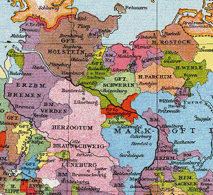
Deutsch: Grafschaft Dannenberg um 1250 English: Map of the County of Dannenberg and surrounding area circa 1250. |
| Date | |
| Source | Allgemeiner historischer Handatlas |
| Author | Gustav Droysen |
| Other versions | Image:Grafschaften_Holstein_Ratzeburg_Schwerin_Dannenberg_Luechow_1250.png, Image:Grafschaft_Dannenberg_1250.png |
|
This work is in the public domain in its country of origin and other countries and areas where the copyright term is the author's life plus 70 years or fewer. | |
| This file has been identified as being free of known restrictions under copyright law, including all related and neighboring rights. | |
File history
Click on a date/time to view the file as it appeared at that time.
| Date/Time | Thumbnail | Dimensions | User | Comment | |
|---|---|---|---|---|---|
| current | 17:21, 29 August 2007 | | 310 × 283 (85 KB) | Alma (talk | contribs) | {{Information |Description=de:Grafschaft Dannenberg um 1250 |Source=Allgemeiner historischer Handatlas |Date=1886 |Author=Gustav Droysen |Permission= |other_versions= }} {{pd-old}} |
You cannot overwrite this file.
File usage on Commons
There are no pages that use this file.
File usage on other wikis
The following other wikis use this file:
- Usage on en.wikipedia.org
- Usage on et.wikipedia.org
- Usage on la.wikipedia.org
- Usage on lt.wikipedia.org