File:Grade II Listed St Peter's Church, Newchurch, Monmouthshire (geograph 6960725).jpg
Jump to navigation
Jump to search

Size of this preview: 533 × 600 pixels. Other resolutions: 213 × 240 pixels | 427 × 480 pixels | 910 × 1,024 pixels.
Original file (910 × 1,024 pixels, file size: 362 KB, MIME type: image/jpeg)
Captions
Captions
Add a one-line explanation of what this file represents
Summary
[edit].jpg&action=edit§ion=1)
| Description |
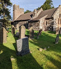
English: Grade II Listed St Peter's Church, Newchurch, Monmouthshire. In the Church in Wales Diocese of Monmouth. A leaflet available at the church entrance states that the church is located at 800 ft (244m) above sea level in a churchyard with views of the Bristol Channel and beyond to the Cotswold scarp. The land was granted to Tintern Abbey after the Norman Invasion. Monks cleared the area to establish the Parish of Newchurch. In 1291 the land was given to Roger Bigod in exchange for land at Woolaston. Bigod provided the Church of St Peter. The church rebuild and restoration of 1864 left intact the squat 14th century west tower with battlements. |
| Date | |
| Source | From geograph.org.uk |
| Author | Jaggery |
| Permission (Reusing this file) |
Creative Commons Attribution Share-alike license 2.0 |
| Attribution (required by the license) | Jaggery / Grade II Listed St Peter's Church, Newchurch, Monmouthshire / |
| Camera location | | View this and other nearby images on: OpenStreetMap |
|---|
.jpg¶ms=051.674055_N_-002.790558_E_globe:Earth_type:camera_source:geograph-osgb36(ST45439755)_heading:270.00&language=en)
| Object location | | View this and other nearby images on: OpenStreetMap |
|---|
.jpg¶ms=051.674050_N_-002.790990_E_globe:Earth_class:object_type:object_source:geograph-osgb36(ST45409755)_heading:270.00&language=en)
Licensing
[edit].jpg&action=edit§ion=2)

|
This image was taken from the Geograph project collection. See this photograph's page on the Geograph website for the photographer's contact details. The copyright on this image is owned by Jaggery and is licensed for reuse under the Creative Commons Attribution-ShareAlike 2.0 license.
|
This file is licensed under the Creative Commons Attribution-Share Alike 2.0 Generic license.
Attribution: Jaggery
- You are free:
- to share – to copy, distribute and transmit the work
- to remix – to adapt the work
- Under the following conditions:
- attribution – You must give appropriate credit, provide a link to the license, and indicate if changes were made. You may do so in any reasonable manner, but not in any way that suggests the licensor endorses you or your use.
- share alike – If you remix, transform, or build upon the material, you must distribute your contributions under the same or compatible license as the original.
File history
Click on a date/time to view the file as it appeared at that time.
| Date/Time | Thumbnail | Dimensions | User | Comment | |
|---|---|---|---|---|---|
| current | 21:42, 15 September 2021 | | 910 × 1,024 (362 KB) | Salen9 (talk | contribs) | == {{int:filedesc}} == {{Information |Description={{en|1=Grade II Listed St Peter's Church, Newchurch, Monmouthshire}} |Source=From [https://www.geograph.org.uk/photo/6960725 geograph.org.uk] |Date=2021-09-12 |Author=[https://www.geograph.org.uk/profile/39302 Jaggery] |Permission=Creative Commons Attribution Share-alike license 2.0 |Other fields={{Credit line |Author=Jaggery |License=[https://creativecommons.org/licenses/by-sa/2.0/ CC BY-SA 2.0] |Other=''Grade II Listed St Peter's Church,... |
You cannot overwrite this file.
File usage on Commons
The following page uses this file:
File usage on other wikis
The following other wikis use this file:
- Usage on www.wikidata.org
.jpg&oldid=660288556)