File:Gorhey, Eglise Saint-Paul.jpg
Jump to navigation
Jump to search

Size of this preview: 800 × 559 pixels. Other resolutions: 320 × 224 pixels | 640 × 448 pixels | 1,024 × 716 pixels | 1,280 × 895 pixels | 2,560 × 1,790 pixels | 3,226 × 2,256 pixels.
Original file (3,226 × 2,256 pixels, file size: 754 KB, MIME type: image/jpeg)
Captions
Captions
Add a one-line explanation of what this file represents
| Description |
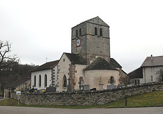
Français : L'église Saint-Paul à Gorhey Deutsch: Kirche St. Paulus in Gorhey |
| Date | |
| Source | Self-photographed |
| Author | Rauenstein |
| Permission (Reusing this file) |
This file is licensed under the Creative Commons Attribution-Share Alike 3.0 Unported, 2.5 Generic, 2.0 Generic and 1.0 Generic license.
|
| Object location | | View this and other nearby images on: OpenStreetMap |
|---|
|
This building is en partie classé, en partie inscrit au titre des monuments historiques de la France. It is indexed in the base Mérimée, a database of architectural heritage maintained by the French Ministry of Culture, under the reference PA00107179
|
File history
Click on a date/time to view the file as it appeared at that time.
| Date/Time | Thumbnail | Dimensions | User | Comment | |
|---|---|---|---|---|---|
| current | 04:03, 11 December 2009 | | 3,226 × 2,256 (754 KB) | Rauenstein (talk | contribs) | {{Information |Description={{fr|L'église Saint-Paul à Gorhey}} {{de|Kirche Saint-Paul in Gorhey}} |Source=own photograph |Date=2009-12-05 |Author=Rauenstein |Permission={{cc-by-sa-3.0,2.5,2.0,1.0}} |othe |
You cannot overwrite this file.
File usage on Commons
The following 3 pages use this file:
File usage on other wikis
The following other wikis use this file:
- Usage on ca.wikipedia.org
- Usage on ceb.wikipedia.org
- Usage on ce.wikipedia.org
- Usage on de.wikipedia.org
- Usage on diq.wikipedia.org
- Usage on en.wikipedia.org
- Usage on es.wikipedia.org
- Usage on eu.wikipedia.org
- Usage on fr.wikipedia.org
- Usage on hu.wikipedia.org
- Usage on it.wikipedia.org
- Usage on ku.wikipedia.org
- Usage on mg.wikipedia.org
- Usage on nl.wikipedia.org
- Usage on oc.wikipedia.org
- Usage on pl.wikipedia.org
- Usage on pt.wikipedia.org
- Usage on sh.wikipedia.org
- Usage on sk.wikipedia.org
- Usage on sr.wikipedia.org
- Usage on sv.wikipedia.org
- Usage on tt.wikipedia.org
- Usage on uk.wikipedia.org
- Usage on uz.wikipedia.org
- Usage on vec.wikipedia.org
- Usage on www.wikidata.org
- Usage on zh-min-nan.wikipedia.org
- Usage on zh.wikipedia.org