File:Gopher Snake (11970133425).jpg
Jump to navigation
Jump to search

Size of this preview: 367 × 598 pixels. Other resolutions: 147 × 240 pixels | 294 × 480 pixels | 739 × 1,205 pixels.
Original file (739 × 1,205 pixels, file size: 381 KB, MIME type: image/jpeg)
Captions
Captions
Add a one-line explanation of what this file represents
Summary
[edit].jpg&action=edit§ion=1)
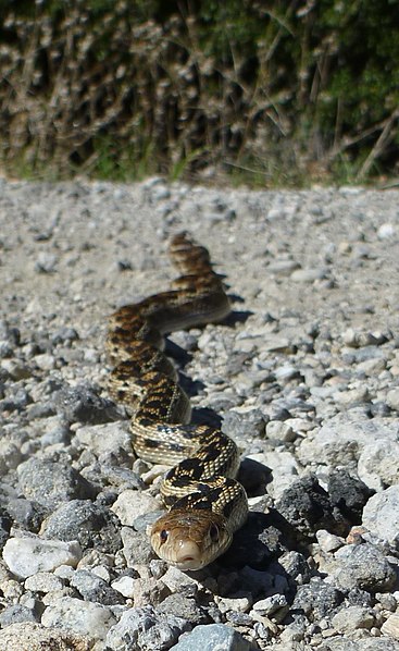
| Description | This non-venomous snake is often mistaken for a diamondback rattlesnake. However, it can be easily distinguished from a rattlesnake by the lack of black and white banding on its tail, as well as by the shape of its head, which is narrower than a rattlesnake's. |
| Date | |
| Source | Gopher Snake |
| Author | National Park Service from USA |
| Camera location | | View this and other nearby images on: OpenStreetMap |
|---|
.jpg¶ms=034.156566_N_-118.746081_E_globe:Earth_type:camera_source:Flickr_&language=en)
Licensing
[edit].jpg&action=edit§ion=2)
| This image or media file contains material based on a work of a National Park Service employee, created as part of that person's official duties. As a work of the U.S. federal government, such work is in the public domain in the United States. See the NPS website and NPS copyright policy for more information. |
| This image was originally posted to Flickr by Santa Monica Mountains National Recreation Area at https://flickr.com/photos/38729417@N06/11970133425 (archive). It was reviewed on 24 January 2018 by FlickreviewR 2 and was confirmed to be licensed under the terms of the Public Domain Mark. |
File history
Click on a date/time to view the file as it appeared at that time.
| Date/Time | Thumbnail | Dimensions | User | Comment | |
|---|---|---|---|---|---|
| current | 20:59, 24 January 2018 | | 739 × 1,205 (381 KB) | Artix Kreiger 2 (talk | contribs) | Transferred from Flickr via Flickr2Commons |
You cannot overwrite this file.
File usage on Commons
There are no pages that use this file.
.jpg&oldid=913105797)