File:Go Blue, M Club Supports You Banner, Michigan Stadium, University of Michigan, Ann Arbor, Michigan (21557333240).jpg

Original file (4,000 × 3,000 pixels, file size: 5.85 MB, MIME type: image/jpeg)
Captions
Captions
Summary
[edit].jpg&action=edit§ion=1)
| Description |
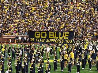
One of the most recognizable and exciting game day entrances in college football, the GO BLUE banner has been a staple at Michigan football games since 1962. This tradition has been performed by the Wolverines for nearly 50 years prior to the kickoff of every game at the Big House. After exiting the locker room, the team comes down the tunnel in unison. From that small hole at midfield, all the players can view is the large 30 by five foot banner that extends across midfield. On the directive, the players and staff run toward the banner that reads: GO BLUE M CLUB SUPPORTS YOU How did this tradition come about? Though the Graduate "M" Club made the permanent banner, it was the Undergraduate Club that started the tradition with a simple yellow block "M" on a six-foot wide strip of fabric. On the Friday practice before the 1962 team's homecoming game against Illinois, the "M" Club assembled all the non-football letterwinners to form two lines as the players ran off the field toward the locker rooms in Yost Field House. The club was given permission by then coach Bump Elliott to form the flag tunnel before the game the next day, and the rest is history. <a href="http://www.mgoblue.com/sports/m-footbl/spec-rel/021910aad.html" rel="nofollow">www.mgoblue.com/sports/m-footbl/spec-rel/021910aad.html</a> |
| Date | |
| Source | Go Blue, M Club Supports You Banner, Michigan Stadium, University of Michigan, Ann Arbor, Michigan |
| Author | Ken Lund from Reno, Nevada, USA |
| Camera location | | View this and other nearby images on: OpenStreetMap |
|---|
.jpg¶ms=042.265377_N_-083.749159_E_globe:Earth_type:camera_source:Flickr_&language=en)
Licensing
[edit].jpg&action=edit§ion=2)
- You are free:
- to share – to copy, distribute and transmit the work
- to remix – to adapt the work
- Under the following conditions:
- attribution – You must give appropriate credit, provide a link to the license, and indicate if changes were made. You may do so in any reasonable manner, but not in any way that suggests the licensor endorses you or your use.
- share alike – If you remix, transform, or build upon the material, you must distribute your contributions under the same or compatible license as the original.
| This image was originally posted to Flickr by Ken Lund at https://flickr.com/photos/75683070@N00/21557333240 (archive). It was reviewed on 15 October 2018 by FlickreviewR 2 and was confirmed to be licensed under the terms of the cc-by-sa-2.0. |
File history
Click on a date/time to view the file as it appeared at that time.
| Date/Time | Thumbnail | Dimensions | User | Comment | |
|---|---|---|---|---|---|
| current | 07:28, 15 October 2018 | | 4,000 × 3,000 (5.85 MB) | SecretName101 (talk | contribs) | Transferred from Flickr via #flickr2commons |
You cannot overwrite this file.
File usage on Commons
There are no pages that use this file.
File usage on other wikis
The following other wikis use this file:
.jpg)
.jpg&oldid=888635756)