File:Glien.png
Jump to navigation
Jump to search
Size of this preview: 766 × 600 pixels. Other resolutions: 307 × 240 pixels | 613 × 480 pixels | 981 × 768 pixels | 1,280 × 1,002 pixels | 1,814 × 1,420 pixels.
Original file (1,814 × 1,420 pixels, file size: 339 KB, MIME type: image/png)
Captions
Captions
Add a one-line explanation of what this file represents
Summary
[edit]
| Description |
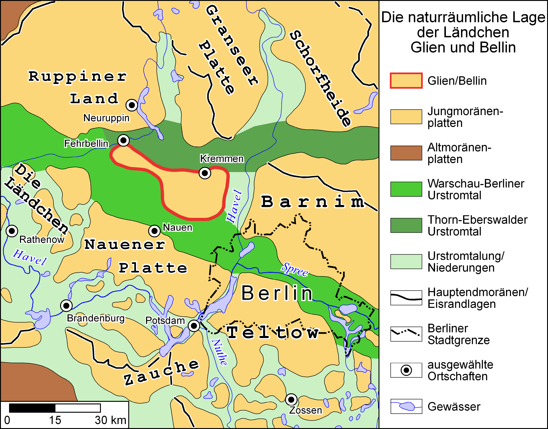
Deutsch: Die naturräumliche Lage der Ländchen Glien und Bellin |
| Date | |
| Source |
Deutsch: vereinfacht nach Atlas zur Geologie von Brandenburg, Werner Stackebrandt und Volker Manhenke (Hrsg.), Landesamt für Geowissenschaften und Rohstoffe Brandenburg (heute Landesamt für Bergbau, Geologie und Rohstoffe Brandenburg, LBGR) 2002, 2. Aufl., 142 S., 43 Karten, ISBN 3-9808157-0-6 |
| Author | Zeichnung von Grabenstedt 11:02, 26. Jul. 2007 (CEST) |

|
Permission is granted to copy, distribute and/or modify this document under the terms of the GNU Free Documentation License, Version 1.2 or any later version published by the Free Software Foundation; with no Invariant Sections, no Front-Cover Texts, and no Back-Cover Texts. A copy of the license is included in the section entitled GNU Free Documentation License. |
| This file is licensed under the Creative Commons Attribution-Share Alike 3.0 Unported license. | ||
| ||
| This licensing tag was added to this file as part of the GFDL licensing update. |
File history
Click on a date/time to view the file as it appeared at that time.
| Date/Time | Thumbnail | Dimensions | User | Comment | |
|---|---|---|---|---|---|
| current | 09:30, 26 July 2007 | | 1,814 × 1,420 (339 KB) | Grabenstedt (talk | contribs) | == Beschreibung, Quelle == {{Information |Beschreibung = Die naturräumliche Lage der Ländchen Glien und Bellin |Quelle = vereinfacht nach ''Atlas zur Geologie von Brandenburg'', Werner Stackebrandt und Volker Manhenke (Hrsg.), Landesamt für Geowissensc |
| 09:25, 26 July 2007 |  | 1,827 × 1,438 (365 KB) | Grabenstedt (talk | contribs) | == Beschreibung, Quelle == {{Information |Beschreibung = Die naturräumliche Lage der Ländchen Glien und Bellin |Quelle = vereinfacht nach ''Atlas zur Geologie von Brandenburg'', Werner Stackebrandt und Volker Manhenke (Hrsg.), Landesamt für Geowissensc | |
| 09:05, 26 July 2007 |  | 1,827 × 1,438 (366 KB) | Grabenstedt (talk | contribs) | == Beschreibung, Quelle == {{Information |Beschreibung = Die naturräumliche Lage der Ländchen Glien und Bellin |Quelle = vereinfacht nach ''Atlas zur Geologie von Brandenburg'', Werner Stackebrandt und Volker Manhenke (Hrsg.), Landesamt für Geowissensc | |
| 09:02, 26 July 2007 |  | 1,814 × 1,420 (341 KB) | Grabenstedt (talk | contribs) | {{Information |Beschreibung = Die naturräumliche Lage der Ländchen Glien und Bellin |Quelle = vereinfacht nach ''Atlas zur Geologie von Brandenburg'', Werner Stackebrandt und Volker Manhenke (Hrsg.), Landesamt für Geowissenschaften und Rohstoffe Brande |
You cannot overwrite this file.
File usage on Commons
There are no pages that use this file.
File usage on other wikis
The following other wikis use this file:
- Usage on de.wikipedia.org
- Usage on www.wikidata.org