File:Glengall Street becomes 'One-Way', Belfast (2-2) - geograph.org.uk - 1501762.jpg
Jump to navigation
Jump to search
No higher resolution available.
Glengall_Street_becomes_'One-Way',_Belfast_(2-2)_-_geograph.org.uk_-_1501762.jpg (640 × 480 pixels, file size: 88 KB, MIME type: image/jpeg)
Captions
Captions
Add a one-line explanation of what this file represents
Summary
[edit]_-_geograph.org.uk_-_1501762.jpg&action=edit§ion=1)
| Description |
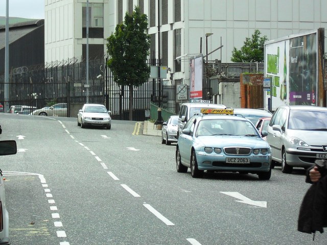
English: Glengall Street becomes 'One-Way', Belfast (2/2) Effectively as of 21st September 2009, Glengall Street is becoming mostly closed to two way traffic. The image shows the newly painted road markings. Buses however, will still be able to leave the Europa Buscentre and join Durham Street.
Glengall Street (a busy link between Durham Street and Gt. Victoria Street) remains to be a good shortcut for traffic leaving the M1 at Broadway and approaching the city centre by the Donegall Road and Sandy Row. Buses travelling north on Gt. Vic. St. are now forced to 'go round the long way' by the Grosvenor Road. |
| Date | |
| Source | From geograph.org.uk |
| Author | Dean Molyneaux |
| Attribution (required by the license) | Dean Molyneaux / Glengall Street becomes 'One-Way', Belfast (2/2) / |
| Camera location | | View this and other nearby images on: OpenStreetMap |
|---|
_-_geograph.org.uk_-_1501762.jpg¶ms=054.595300_N_-005.935400_E_globe:Earth_type:camera_source:geograph-irishgrid(J33497385)_heading:270.00&language=en)
| Object location | | View this and other nearby images on: OpenStreetMap |
|---|
_-_geograph.org.uk_-_1501762.jpg¶ms=054.595230_N_-005.936600_E_globe:Earth_class:object_type:object_source:geograph-irishgrid(J33417384)_heading:270.00&language=en)
Licensing
[edit]_-_geograph.org.uk_-_1501762.jpg&action=edit§ion=2)

|
This image was taken from the Geograph project collection. See this photograph's page on the Geograph website for the photographer's contact details. The copyright on this image is owned by Dean Molyneaux and is licensed for reuse under the Creative Commons Attribution-ShareAlike 2.0 license.
|
This file is licensed under the Creative Commons Attribution-Share Alike 2.0 Generic license.
Attribution: Dean Molyneaux
- You are free:
- to share – to copy, distribute and transmit the work
- to remix – to adapt the work
- Under the following conditions:
- attribution – You must give appropriate credit, provide a link to the license, and indicate if changes were made. You may do so in any reasonable manner, but not in any way that suggests the licensor endorses you or your use.
- share alike – If you remix, transform, or build upon the material, you must distribute your contributions under the same or compatible license as the original.
File history
Click on a date/time to view the file as it appeared at that time.
| Date/Time | Thumbnail | Dimensions | User | Comment | |
|---|---|---|---|---|---|
| current | 20:44, 2 March 2011 | | 640 × 480 (88 KB) | GeographBot (talk | contribs) | == {{int:filedesc}} == {{Information |description={{en|1=Glengall Street becomes 'One-Way', Belfast (2/2) Effectively as of 21st September 2009, Glengall Street is becoming mostly closed to two way traffic. The image shows the newly painted road markings. |
You cannot overwrite this file.
File usage on Commons
There are no pages that use this file.
_-_geograph.org.uk_-_1501762.jpg&oldid=716167951)