File:Gleisplan Garmisch-Partenkirchen 1960 2022.png
Jump to navigation
Jump to search
Size of this preview: 589 × 600 pixels. Other resolutions: 236 × 240 pixels | 471 × 480 pixels | 754 × 768 pixels | 1,006 × 1,024 pixels | 2,299 × 2,341 pixels.
Original file (2,299 × 2,341 pixels, file size: 203 KB, MIME type: image/png)
Captions
Captions
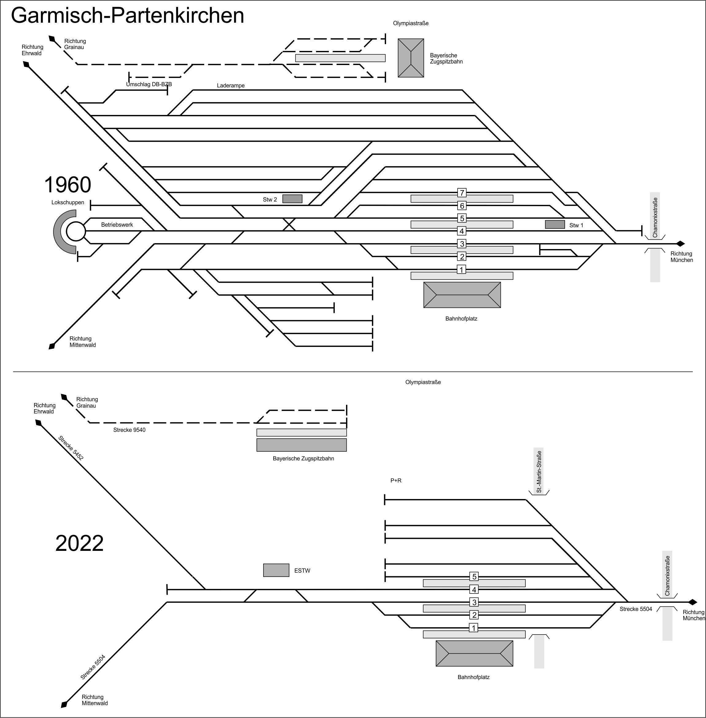
Track plans of Garmisch-Partenkirchen railway station
Summary
[edit]
| Description |
Deutsch: Gleispläne des Bahnhofs Garmisch-Partenkirchen abgeleitet von Luftbildern der Jahre 1960 und 2022.
English: Track plans of Garmisch-Partenkirchen railway station derived from aerial images of the years 1960 and 2022 |
| Date | |
| Source | Own work Own work based on aerial images taken on 17 Jun 1960 and 12 Jun 2022 provided by https://www.ldbv.bayern.de/vermessung/luftbilder/recherchestation.html |
| Author | Periphrastika |
| Camera location | | View this and other nearby images on: OpenStreetMap |
|---|
Licensing
[edit]
I, the copyright holder of this work, hereby publish it under the following license:
| This file is made available under the Creative Commons CC0 1.0 Universal Public Domain Dedication. | |
| The person who associated a work with this deed has dedicated the work to the public domain by waiving all of their rights to the work worldwide under copyright law, including all related and neighboring rights, to the extent allowed by law. You can copy, modify, distribute and perform the work, even for commercial purposes, all without asking permission.
|
File history
Click on a date/time to view the file as it appeared at that time.
| Date/Time | Thumbnail | Dimensions | User | Comment | |
|---|---|---|---|---|---|
| current | 11:49, 3 May 2024 | | 2,299 × 2,341 (203 KB) | Periphrastika (talk | contribs) | Uploaded own work with UploadWizard |
You cannot overwrite this file.
File usage on Commons
The following 4 pages use this file: