File:Girvan Old Grave Alex Ross.jpg
Original file (3,710 × 5,584 pixels, file size: 4.25 MB, MIME type: image/jpeg)
Captions
Captions
Summary
[edit]
| Description |
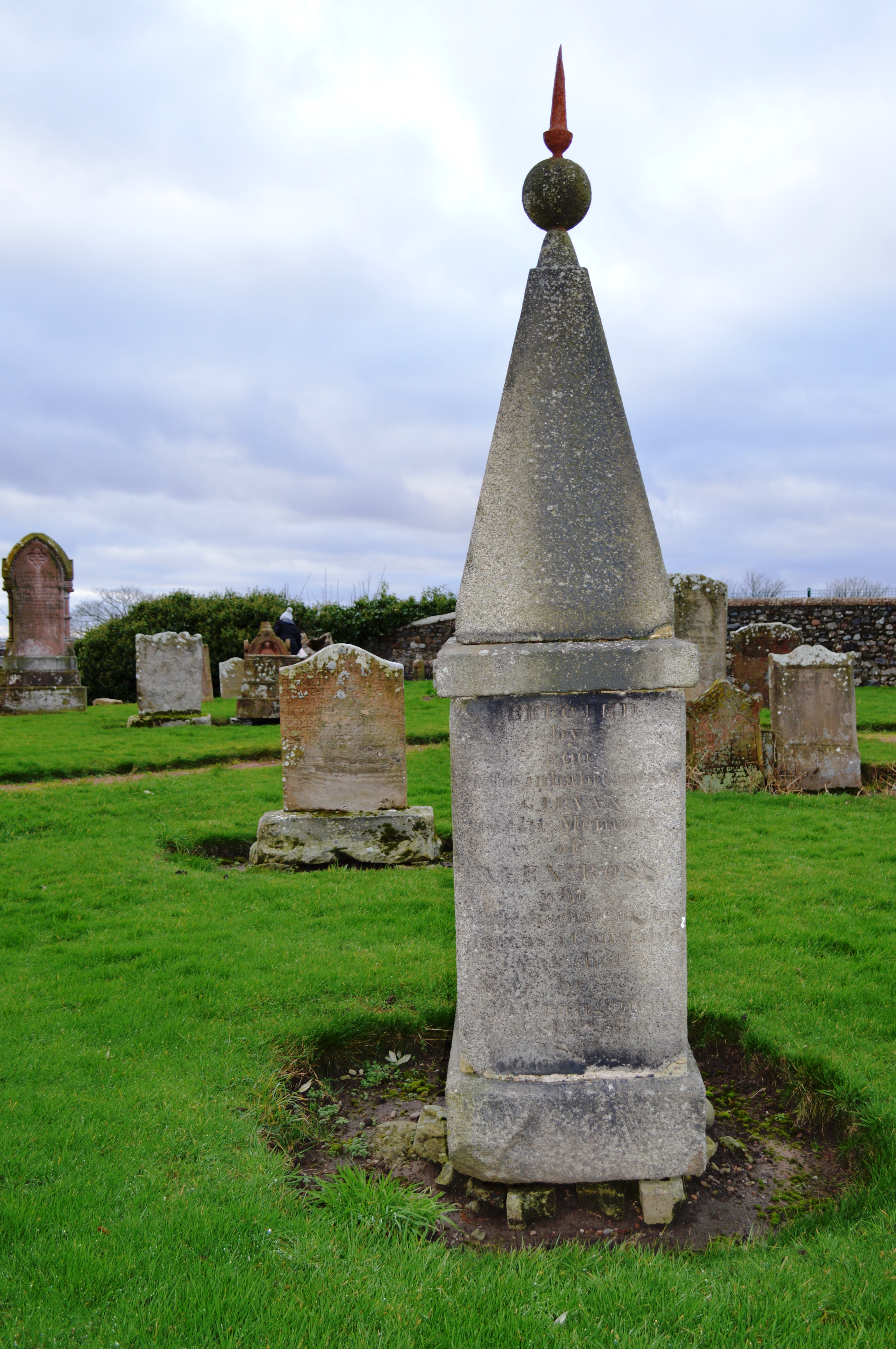
English: Girvan, in Carrick, South Ayrshire, was originally a fishing port and in 1668, it became a municipal burgh incorporated by charter. The opening of the railways, initially with the Maybole and Girvan Railway at the end of the 1850s, encouraged the development of Girvan as a seaside resort. Beneath rolling hills to the East of the town Girvan’s long beach provides great views towards the islands of Ailsa Craig and Arran as well as, on a clear day, The Mull of Kintyre and Northern Ireland. Girvan Old Street Churchyard Burial Ground is adjacent to the A77, north of the town centre. The graveyard surrounds the site of the former parish church mentioned in 1296 and dedicated to St Cuthbert.
The trouble started on 25th April when ‘Reform Movement’ protestors, paraded through the town and were attacked by members of the ‘Orange Movement’. For the next six months there were continuous running battles between the two factions even though the Reformers were of no particular religious persuasion and there were many casualties on both sides. On the day Constable Ross was murdered several other constables and people from the town were severely injured. (Samuel Waugh, the Orangeman who fired the shot that killed Ross, was later arrested at Suie on the Newton Stewart Hill Road having made his escape to there by way of the village of Barr. Following his conviction, Waugh, a former soldier in the Downshire Militia, was hanged on 19 January 1832.) Special Constable “Alex” Ross, a fisherman to trade, was buried in Old Street Cemetery and his grave is marked by a low stone of obelisk design surmounted by a ball and spike. [Text courtesy of David M Hunter - FSA Scot.] The Scotch Mist Gallery contains photographs of historic buildings, monuments, memorials and people. |
| Date | |
| Source | Own work |
| Author | Scotch Mist |
| Camera location | | View this and other nearby images on: OpenStreetMap |
|---|
Licensing
[edit]
- You are free:
- to share – to copy, distribute and transmit the work
- to remix – to adapt the work
- Under the following conditions:
- attribution – You must give appropriate credit, provide a link to the license, and indicate if changes were made. You may do so in any reasonable manner, but not in any way that suggests the licensor endorses you or your use.
- share alike – If you remix, transform, or build upon the material, you must distribute your contributions under the same or compatible license as the original.
File history
Click on a date/time to view the file as it appeared at that time.
| Date/Time | Thumbnail | Dimensions | User | Comment | |
|---|---|---|---|---|---|
| current | 18:04, 15 March 2019 | | 3,710 × 5,584 (4.25 MB) | SteinsplitterBot (talk | contribs) | Bot: Image rotated by 270° (EXIF-Orientation set from 6 to 1, rotated 0°) |
| 15:31, 15 March 2019 |  | 5,584 × 3,710 (4.25 MB) | Scotch Mist (talk | contribs) | User created page with UploadWizard |
You cannot overwrite this file.
File usage on Commons
The following page uses this file: