File:Gilsonite (uintaite) (Big Bonanza Vein intruded in the Uinta Formation, Middle Eocene; Bonanza, Utah, USA) 4.jpg

Original file (2,755 × 2,133 pixels, file size: 3.46 MB, MIME type: image/jpeg)
Captions
Captions
Summary
[edit]_(Big_Bonanza_Vein_intruded_in_the_Uinta_Formation,_Middle_Eocene;_Bonanza,_Utah,_USA)_4.jpg&action=edit§ion=1)
| Description |
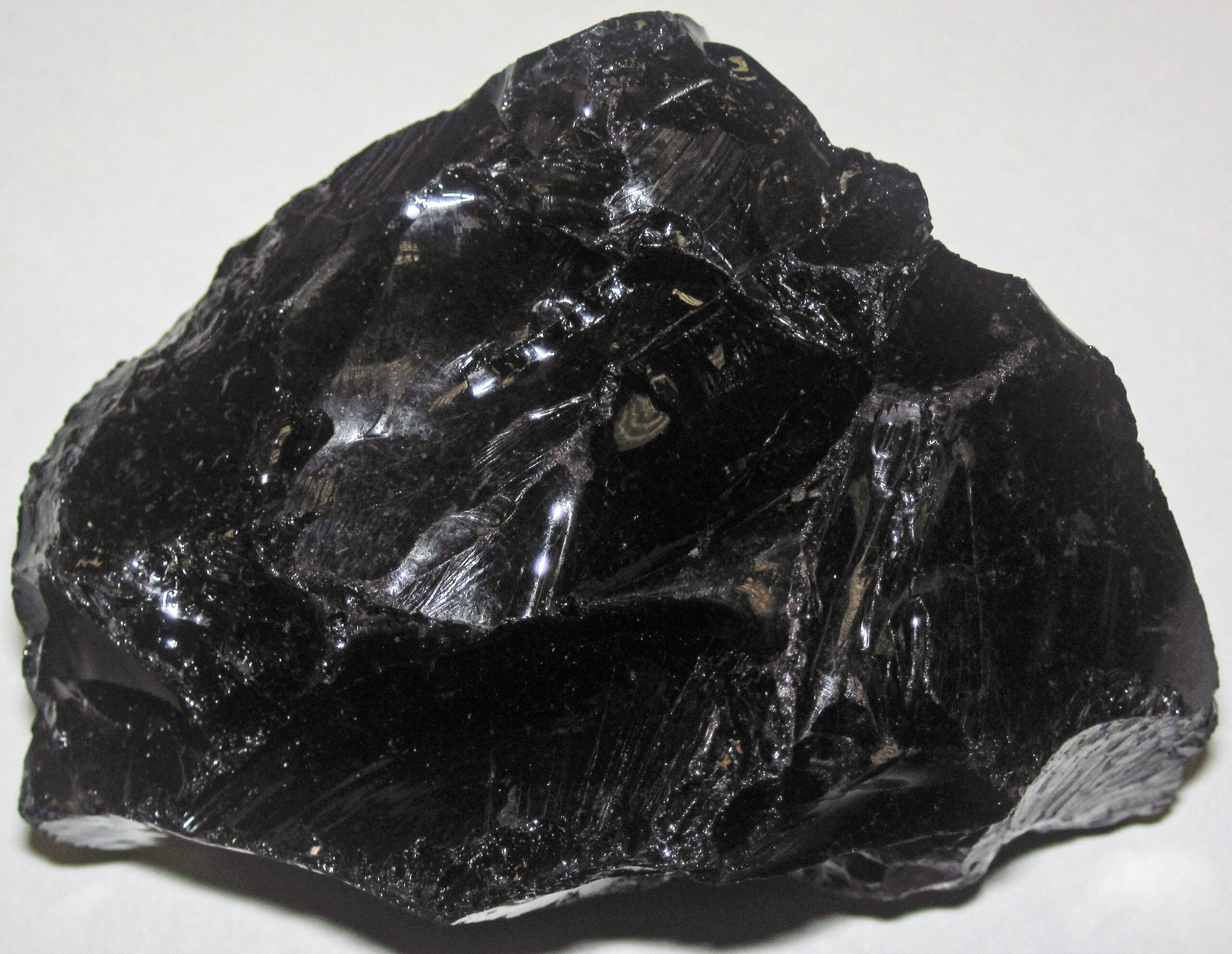
English: Gilsonite from the Tertiary of Utah, USA. (~7.4 centimetres (2.9 in) across at its widest)
Gilsonite (a.k.a. uintaite) is a variety of asphaltite - it's a solid hydrocarbon - basically solidified oil. Gilsonite usually has the appearance of obsidian or anthracite coal. It is jet black in color, very lightweight, brittle, and has a conchoidal fracture. The largest “deposits” of gilsonite in the world are in the Uinta Basin of northeastern Utah, USA. Gilsonite occurs there as vertical NW-SE trending veins intruded within the Eocene-aged Uinta Formation. The source of the hydrocarbons is organic-rich beds in the underlying Green River Formation (Eocene) and Wasatch Formation (Paleocene). Gilsonite is not readily combustible and is not a fuel, but it does have economic value. Gilsonite is mined in northeastern Utah and processed and is used in numerous products and applications (e.g., see: www.geospectra.net/kite/gilsonite/gilson.htm). Seen here is a gilsonite sample from the Big Bonanza Vein (also known as the Independent Dike or the Independent Vein; other names for the same dike include East Bonanza Vein and Bonanza Vein; the latter designation has been applied to more than 1 gilsonite vein in the area). The dike ranges from about 5 to 14 feet wide and averages over 10 feet wide over a 3 mile stretch. It intrudes the Uinta Formation and was probably emplaced ~10 to 30 million years ago. Locality: unrecorded/undisclosed locality along the Big Bonanza Vein (Independent Dike), near the town of Bonanza, eastern Uintah County, northeastern Utah, USA |
| Date | |
| Source | https://www.flickr.com/photos/47445767@N05/49035142238/ |
| Author | James St. John |
Licensing
[edit]_(Big_Bonanza_Vein_intruded_in_the_Uinta_Formation,_Middle_Eocene;_Bonanza,_Utah,_USA)_4.jpg&action=edit§ion=2)
- You are free:
- to share – to copy, distribute and transmit the work
- to remix – to adapt the work
- Under the following conditions:
- attribution – You must give appropriate credit, provide a link to the license, and indicate if changes were made. You may do so in any reasonable manner, but not in any way that suggests the licensor endorses you or your use.
| This image was originally posted to Flickr by James St. John at https://flickr.com/photos/47445767@N05/49035142238. It was reviewed on 18 October 2020 by FlickreviewR 2 and was confirmed to be licensed under the terms of the cc-by-2.0. |
File history
Click on a date/time to view the file as it appeared at that time.
| Date/Time | Thumbnail | Dimensions | User | Comment | |
|---|---|---|---|---|---|
| current | 02:42, 18 October 2020 | | 2,755 × 2,133 (3.46 MB) | Ser Amantio di Nicolao (talk | contribs) | Uploaded a work by James St. John from https://www.flickr.com/photos/47445767@N05/49035142238/ with UploadWizard |
You cannot overwrite this file.
File usage on Commons
The following page uses this file:
File usage on other wikis
The following other wikis use this file:
- Usage on en.wikipedia.org
- Usage on fa.wikipedia.org
- Usage on uk.wikipedia.org
- Usage on www.wikidata.org
_(Big_Bonanza_Vein_intruded_in_the_Uinta_Formation,_Middle_Eocene;_Bonanza,_Utah,_USA)_4.jpg&oldid=708685086)