File:Gfs Ravensberg 1645.jpg
Jump to navigation
Jump to search
Size of this preview: 482 × 600 pixels. Other resolutions: 193 × 240 pixels | 386 × 480 pixels | 915 × 1,139 pixels.
Original file (915 × 1,139 pixels, file size: 82 KB, MIME type: image/jpeg)
Captions
Captions
Add a one-line explanation of what this file represents
Summary
[edit]
| Description |
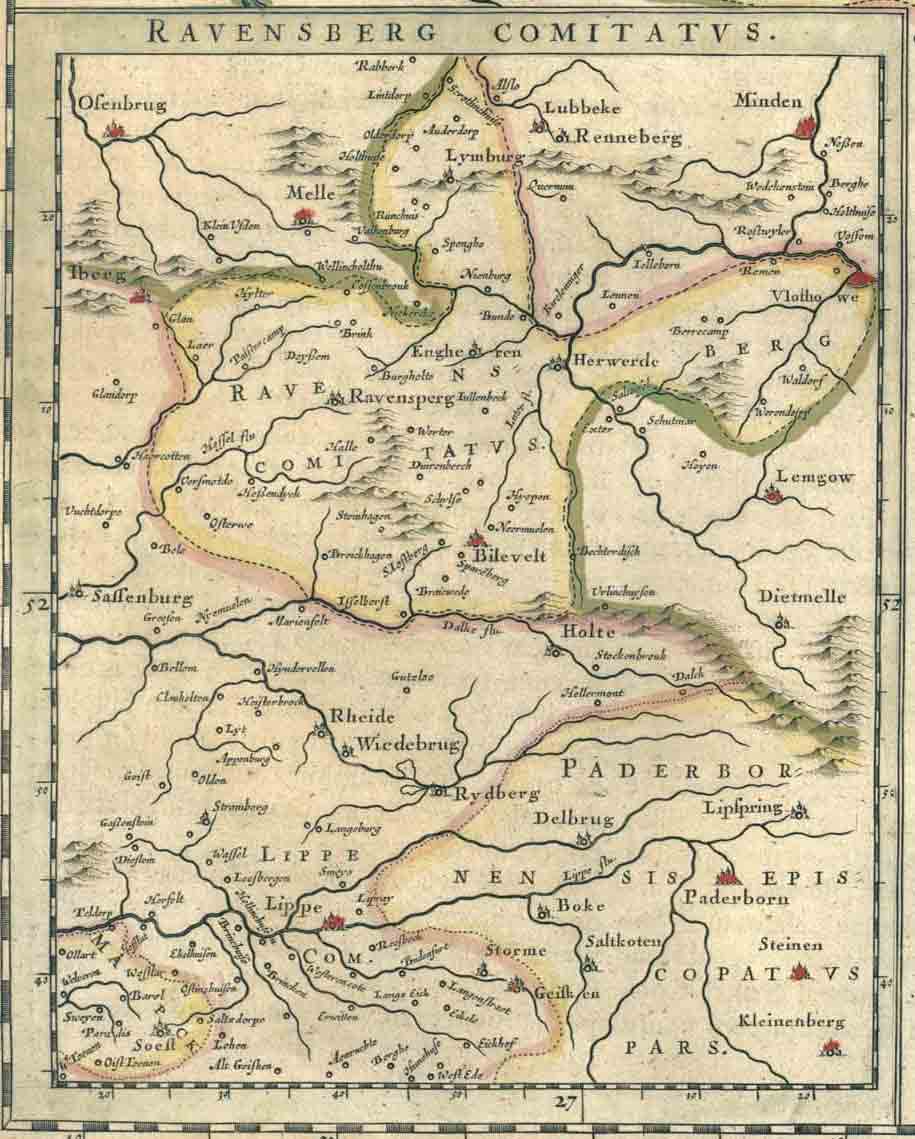
Deutsch: Die Karte "Ravensberg Comitatus", "Grafschaft Ravensberg", ist Teil der Karte "Comitatus Marchia et Ravensberg", "Grafschaft Mark und Ravensberg", aus dem Atlas "Theatrum orbis terrarum, sive, Atlas novus in quo Tabulae et Descriptiones omnium Regionum", übersetzt etwa: "Theater der Welt/Welttheater oder Neuer Atlas mit Karten und Bescheibungen aller Regionen". Hergestellt wurde er von den niederländischen Kartografen und Kupferstechern Willem Janszoon Blaeu and Joan Blaeu. Die Karte stammt aus einer Auflage in lateinischer Sprache, die ab 1645 gedruckt wurde. Schon 1635 gab es einen Vorläufer in niederländischer, deutscher, französischer und lateinischer Sprache. Ab 1662 galt der beständig erweiterte Atlas als Atlas maior, also als wichtigster und Hauptatlas der westlichen Welt. Er ist vor allem als Blaeu-Atlas bekannt. Um die ganze Karte "Comitatus Marchia et Ravensberg" zu betrachten, klicke hier: http://www.library.ucla.edu/yrl/reference/maps/blaeu/marchia.jpg. Den ganzen Atlas kann man sich hier ansehen: http://www.library.ucla.edu/yrl/reference/maps/blaeu/index.htm Beide Links führen zu Seiten, die von der Universität von Kalifornien, Los Angeles (UCLA), USA, digitalisiert wurden. |
| Date |
25 July 2008 (original upload date) |
| Source | GenWiki |
| Author | Unknown author |
| Object location | | View this and other nearby images on: OpenStreetMap |
|---|
Original upload log
[edit]
The original description page was here. All following user names refer to de.wikipedia.
- 2008-07-25 13:19 TUBS 915×1139× (83964 bytes) {{Information |Beschreibung = Übersichtskarte der Grafschaft Ravensberg aus dem "Theatrum orbis terrarum, sive, Atlas novus" von Willem Janszoon und Joan Blaeu, erstellt 1645/1662. |Quelle = GenWiki |Urheber = unbekannt |Datum = 2008 |Genehmigung = |And
Licensing
[edit]
|
This work is in the public domain in its country of origin and other countries and areas where the copyright term is the author's life plus 70 years or fewer. | |
| This file has been identified as being free of known restrictions under copyright law, including all related and neighboring rights. | |
File history
Click on a date/time to view the file as it appeared at that time.
| Date/Time | Thumbnail | Dimensions | User | Comment | |
|---|---|---|---|---|---|
| current | 13:09, 2 March 2009 | | 915 × 1,139 (82 KB) | TUBS (talk | contribs) | {{Information |Description={{de|Übersichtskarte der Grafschaft Ravensberg aus dem "Theatrum orbis terrarum, sive, Atlas novus" von Willem Janszoon und Joan Blaeu, erstellt 1645/1662.}} |Source=Transferred from [http://de.wikipedia.org de.wikipedia]<br/> |
You cannot overwrite this file.
File usage on Commons
There are no pages that use this file.
File usage on other wikis
The following other wikis use this file:
- Usage on de.wikipedia.org
- Usage on eo.wikipedia.org