File:Geyser Valley, Kamchatka (ASTER).jpg
Jump to navigation
Jump to search
Size of this preview: 800 × 320 pixels. Other resolutions: 320 × 128 pixels | 1,000 × 400 pixels.
Original file (1,000 × 400 pixels, file size: 110 KB, MIME type: image/jpeg)
Captions
Captions
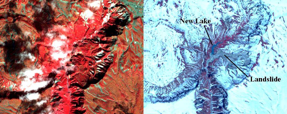
On June 2, a devastating mudslide in the world-renowned Geyser Valley on the Kamchatka Peninsula, Russia virtually obliterated the natural wonder, forcing the emergency evacuation of visitors and national park personnel.
Summary
[edit].jpg&action=edit§ion=1)
| Description |
English: On June 2, a devastating mudslide in the world-renowned Geyser Valley on the Kamchatka Peninsula, Russia virtually obliterated the natural wonder, forcing the emergency evacuation of visitors and national park personnel. The site, which is the Kamchatka Peninsula's main tourist attraction, consists of some 200 thermal pools created by the area's intense volcanic activity, including about 90 geysers covering an area of four square kilometers (2.5 square miles). It is one of only five sites in the world where the impressive eruptions of steam and boiling-hot water can be found. According to witnesses, a powerful mudslide 1.5 kilometers (one mile) long and 200 meters (600 feet) wide buried more than two-thirds of the valley beneath tens of meters of snow, dirt, trees and boulders (right image), and created a temporary lake submerging more geysers. These 2 ASTER images were acquired September 2005 (left) and June 11, 2007, cover an area of 6 x 7.5 km, and are centered near 54.5 degrees north latitude, 160.1 degrees east longitude. |
||
| Date | Taken on 20 September 2007 | ||
| Source |
Geyser Valley, Kamchatka (direct link)
|
||
| Author | NASA/METI/AIST/Japan Space Systems, and U.S./Japan ASTER Science Team |
| Object location | | View this and other nearby images on: OpenStreetMap |
|---|
.jpg¶ms=054.500000_N_0160.100000_E_globe:Earth_class:object_type:object__&language=en)
| This media is a product of the Terra mission Credit and attribution belongs to the Advanced Spaceborne Thermal Emission and Reflection Radiometer (ASTER) team, NASA/METI/AIST/Japan Space Systems |
Licensing
[edit].jpg&action=edit§ion=2)
| This file is in the public domain in the United States because it was solely created by NASA. NASA copyright policy states that "NASA material is not protected by copyright unless noted". (See Template:PD-USGov, NASA copyright policy page or JPL Image Use Policy.) | ||
 |
Warnings:
|
File history
Click on a date/time to view the file as it appeared at that time.
| Date/Time | Thumbnail | Dimensions | User | Comment | |
|---|---|---|---|---|---|
| current | 12:09, 25 June 2023 | 1,000 × 400 (110 KB) | OptimusPrimeBot (talk | contribs) | #Spacemedia - Upload of https://asterweb.jpl.nasa.gov/gallery/images/geysers-both2.jpg via Commons:Spacemedia |
You cannot overwrite this file.
File usage on Commons
There are no pages that use this file.
.jpg&oldid=835378869)