File:Gewaesserdiagramm.svg
Jump to navigation
Jump to search

Size of this PNG preview of this SVG file: 800 × 550 pixels. Other resolutions: 320 × 220 pixels | 640 × 440 pixels | 1,024 × 704 pixels | 1,280 × 880 pixels | 2,560 × 1,760 pixels | 3,200 × 2,200 pixels.
Original file (SVG file, nominally 3,200 × 2,200 pixels, file size: 48 KB)
Captions
Captions
Add a one-line explanation of what this file represents
Summary
[edit]
| Description |
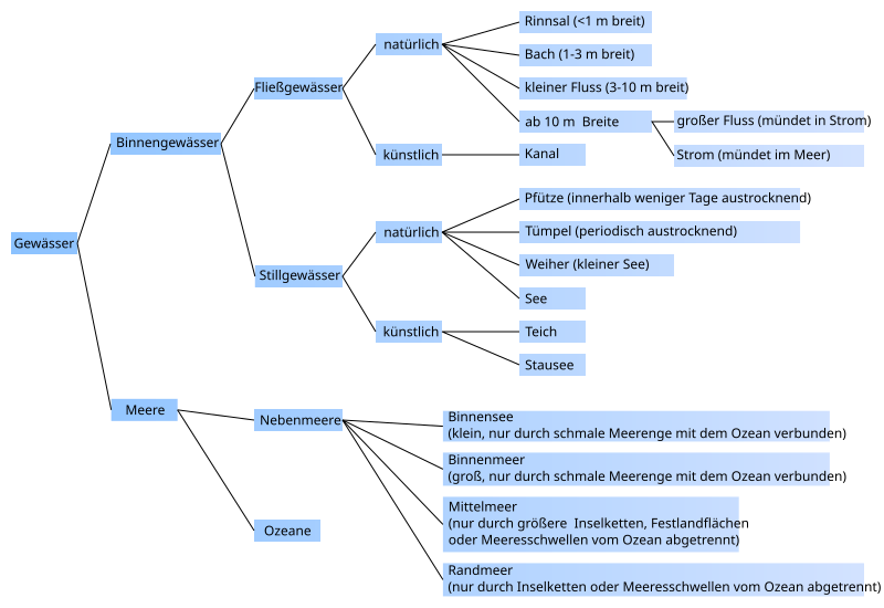
Deutsch: Einteilung der deutschen Namen von verschiedenen Gewässertypen nach physischen Merkmalen English: Ontology of names of various stretches of water in German language according to their physical characteristics |
| Date | |
| Source |
Own work (Original caption: " Selbst Vektorisiert ") |
| Author | Vektorisiert durch Ladyt / Ladyt at de.wikipedia |
| Other versions | Bild:Übersichtneu.jpg |
Licensing
[edit]
| This work has been released into the public domain by its author, Ladyt at German Wikipedia. This applies worldwide. In some countries this may not be legally possible; if so: Ladyt grants anyone the right to use this work for any purpose, without any conditions, unless such conditions are required by law. |
Original upload log
[edit]
Transferred from de.wikipedia to Commons by Brackenheim using CommonsHelper.
The original description page was here. All following user names refer to de.wikipedia.
- 2008-10-26 17:12 Ladyt 3200×2200× (587028 bytes) {{Information |Beschreibung = |Quelle = |Urheber = |Datum = |Genehmigung = |Andere Versionen = |Anmerkungen = }}
- 2008-10-26 12:55 Ladyt 3200×2200× (32847 bytes) {{Information |Beschreibung = Einteilung der verschiedenen Gewässertypen nach Merkmalen geordnet |Quelle = Selbst Vektorisiert |Urheber = Vektorisiert durch ~~~ |Datum = 26.10.2008 |Genehmigung = |Andere Versionen = [[Bild:Übersichtneu.jpg|100px]] |Anm
File history
Click on a date/time to view the file as it appeared at that time.
| Date/Time | Thumbnail | Dimensions | User | Comment | |
|---|---|---|---|---|---|
| current | 10:09, 30 September 2013 | | 3,200 × 2,200 (48 KB) | JasperOCommons (talk | contribs) | Neue Rechtschreibung, Pfad-Text in Text-Text umgewandelt. |
| 10:43, 2 November 2011 |  | 3,200 × 2,200 (573 KB) | File Upload Bot (Magnus Manske) (talk | contribs) | {{BotMoveToCommons|de.wikipedia|year={{subst:CURRENTYEAR}}|month={{subst:CURRENTMONTHNAME}}|day={{subst:CURRENTDAY}}}} {{Information |Description={{de|Einteilung der verschiedenen Gewässertypen nach Merkmalen geordnet}} |Source=Transferred from [http:// |
You cannot overwrite this file.
File usage on Commons
The following page uses this file:
File usage on other wikis
The following other wikis use this file:
- Usage on de.wikipedia.org
- Fließgewässer
- Stillgewässer
- Nebenfluss
- Diskussion:Mausbach (Vichtbach)
- Fluss
- Diskussion:Saubach (Inde)
- Wikipedia:Löschkandidaten/3. November 2009
- Wikipedia:WikiProjekt Kategorien/Diskussionen/2009/November/3
- Diskussion:Weiher (Gewässer)
- Aquasphäre
- Benutzer:Casadopovo/VISUALISIERUNG THERMODYNAMISCHER SYSTEME
- Benutzer Diskussion:Triplec85/Archiv/2023