File:Gespensterwald Nienhagen Panorama.jpg
Original file (5,841 × 3,222 pixels, file size: 7.55 MB, MIME type: image/jpeg)
Captions
Summary
[edit]DescriptionGespensterwald Nienhagen Panorama.jpg |
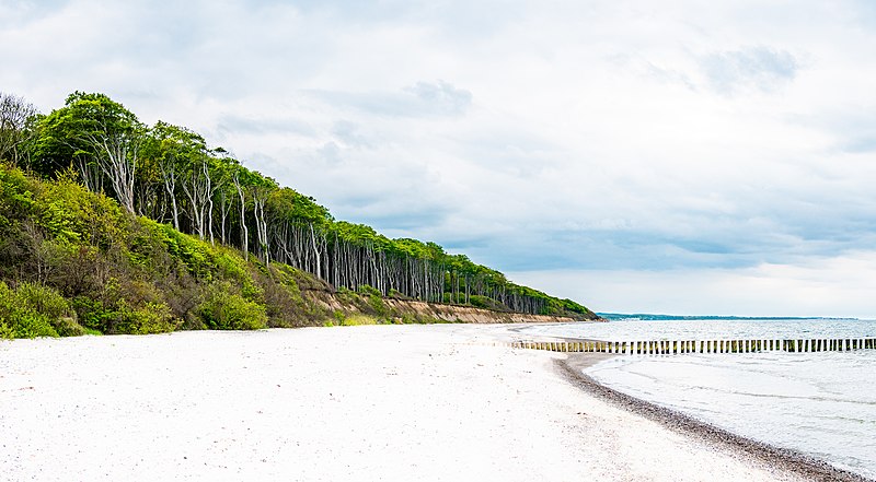
Deutsch: er „Gespensterwald“ ist ein beliebtes Ausflugsziel für Naturliebhaber. Er wurde 1943 zum Naturschutzgebiet erklärt. Mit einer Breite von etwa 100 Metern und einer Länge von ca. 1 300 Metern ist er Teil des Waldgebietes Nienhäger Holz. Ortsansässige sagen, der Wald läge dort, „wo der Wind das Gras mäht“, da die vom Seewind gebogenen Gräser so aussehen, als hätten sie alle die gleiche Länge. |
Date | |
Source | Own work |
Author | Benjamin Peters |
Camera location | 54° 09′ 50.8″ N, 11° 56′ 34.74″ E | View this and other nearby images on: OpenStreetMap | 54.164112; 11.942984 |
---|
Licensing
[edit]- You are free:
- to share – to copy, distribute and transmit the work
- to remix – to adapt the work
- Under the following conditions:
- attribution – You must give appropriate credit, provide a link to the license, and indicate if changes were made. You may do so in any reasonable manner, but not in any way that suggests the licensor endorses you or your use.
- share alike – If you remix, transform, or build upon the material, you must distribute your contributions under the same or compatible license as the original.
This image was uploaded as part of Wiki Loves Earth 2021.
aragonés ∙ asturianu ∙ azərbaycanca ∙ Bahasa Indonesia ∙ Bahasa Melayu ∙ brezhoneg ∙ català ∙ čeština ∙ Cymraeg ∙ Deutsch ∙ eesti ∙ English ∙ español ∙ euskara ∙ français ∙ galego ∙ hrvatski ∙ italiano ∙ latviešu ∙ Nederlands ∙ norsk ∙ norsk bokmål ∙ português ∙ polski ∙ português do Brasil ∙ română ∙ shqip ∙ sicilianu ∙ slovenščina ∙ svenska ∙ Türkçe ∙ Ελληνικά ∙ беларуская (тарашкевіца) ∙ български ∙ македонски ∙ русский ∙ српски / srpski ∙ українська ∙ ქართული ∙ հայերեն ∙ नेपाली ∙ मराठी ∙ বাংলা ∙ മലയാളം ∙ ไทย ∙ 한국어 ∙ 日本語 ∙ 中文 ∙ 中文(台灣) ∙ 中文(简体) ∙ 中文(繁體) ∙ עברית ∙ اردو ∙ العربية ∙ فارسی ∙ +/− |
File history
Click on a date/time to view the file as it appeared at that time.
Date/Time | Thumbnail | Dimensions | User | Comment | |
---|---|---|---|---|---|
current | 15:39, 25 May 2021 | 5,841 × 3,222 (7.55 MB) | Grashuepferhh (talk | contribs) | Uploaded own work with UploadWizard |
You cannot overwrite this file.
File usage on Commons
The following page uses this file:
File usage on other wikis
The following other wikis use this file:
- Usage on de.wikipedia.org
Metadata
This file contains additional information such as Exif metadata which may have been added by the digital camera, scanner, or software program used to create or digitize it. If the file has been modified from its original state, some details such as the timestamp may not fully reflect those of the original file. The timestamp is only as accurate as the clock in the camera, and it may be completely wrong.
Camera manufacturer | Panasonic |
---|---|
Camera model | DC-G9 |
Exposure time | 1/500 sec (0.002) |
F-number | f/4 |
ISO speed rating | 200 |
Date and time of data generation | 17:51, 23 May 2021 |
Lens focal length | 20 mm |
Horizontal resolution | 240 dpi |
Vertical resolution | 240 dpi |
Software used | Adobe Photoshop Lightroom Classic 8.3.1 (Windows) |
File change date and time | 17:33, 25 May 2021 |
Exposure Program | Normal program |
Exif version | 2.31 |
Date and time of digitizing | 17:51, 23 May 2021 |
APEX shutter speed | 8.965784 |
APEX aperture | 4 |
APEX exposure bias | 0.66 |
Maximum land aperture | 1.53125 APEX (f/1.7) |
Metering mode | Center weighted average |
Light source | Unknown |
Flash | Flash did not fire, compulsory flash suppression |
DateTimeOriginal subseconds | 5191 |
DateTimeDigitized subseconds | 5191 |
Color space | sRGB |
Focal plane X resolution | 8,452.6325073242 |
Focal plane Y resolution | 8,452.6325073242 |
Focal plane resolution unit | 3 |
Sensing method | One-chip color area sensor |
File source | Digital still camera |
Scene type | A directly photographed image |
Custom image processing | Normal process |
Exposure mode | Auto exposure |
White balance | Auto white balance |
Digital zoom ratio | 0 |
Focal length in 35 mm film | 40 mm |
Scene capture type | Standard |
Scene control | Low gain up |
Contrast | Normal |
Saturation | Normal |
Sharpness | Normal |
Serial number of camera | XHR1908230003 |
Lens used | LUMIX G 20/F1.7 |
Date metadata was last modified | 19:33, 25 May 2021 |
Unique ID of original document | 54AD49CE8A1A0E6FC6BA1DFD2F979C66 |
IIM version | 4 |
Structured data
Items portrayed in this file
depicts
some value
23 May 2021
54°9'50.803"N, 11°56'34.742"E
0.002 second
20 millimetre
200
- Images from Wiki Loves Earth 2021, DE landscape
- Files with coordinates missing SDC location of creation
- CC-BY-SA-4.0
- Self-published work
- Images from Wiki Loves Earth 2021
- Images from Wiki Loves Earth 2021 in Germany
- Images from Wiki Loves Earth missing SDC depicts
- Images from Wiki Loves Earth missing SDC location of creation
- Images from Wiki Loves Earth 2021, DE-MV
- Uploaded via Campaign:wle-de-mv
- Mecklenburg-Vorpommern photographs taken on 2021-05-23