File:Germany states by area treemap pop-density.svg
Jump to navigation
Jump to search

Size of this PNG preview of this SVG file: 558 × 599 pixels. Other resolutions: 223 × 240 pixels | 447 × 480 pixels | 715 × 768 pixels | 954 × 1,024 pixels | 1,907 × 2,048 pixels | 1,490 × 1,600 pixels.
Original file (SVG file, nominally 1,490 × 1,600 pixels, file size: 5 KB)
Captions
Captions
Add a one-line explanation of what this file represents
| Description |
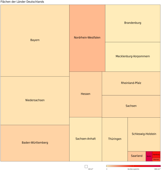
Deutsch: Die Länder Deutschlands nach ihrer Fläche als Treemap geordnet. Die Färbung zeigt die Bevölkerungsdichte.
English: Treemap of the states of Germany sorted by area. Color indicates population density. |
||
| Date | |||
| Source |
Data: Statistische Ämter des Bundes und der Länder (visited 2012-09-23); Treemapping: Google Chart Tools visualization API |
||
| Author | Own work | ||
| Permission (Reusing this file) |
|
||
| SVG development | This chart was created with an unknown SVG tool. |
File history
Click on a date/time to view the file as it appeared at that time.
| Date/Time | Thumbnail | Dimensions | User | Comment | |
|---|---|---|---|---|---|
| current | 22:18, 23 September 2012 | | 1,490 × 1,600 (5 KB) | Mapmarks (talk | contribs) | {{Information |Description= {{de|1=Die Länder Deutschlands nach ihrer Fläche als Treemap geordnet. Die Färbung zeigt die Bevölkerungsdichte.}} {{en|1=Treemap of the states of Germany sorted... |
You cannot overwrite this file.
File usage on Commons
There are no pages that use this file.