File:Gerber Catena by Dawn's backup camera.jpg

Original file (1,024 × 1,024 pixels, file size: 133 KB, MIME type: image/jpeg)
Captions
Captions
Summary
[edit]
| Description |
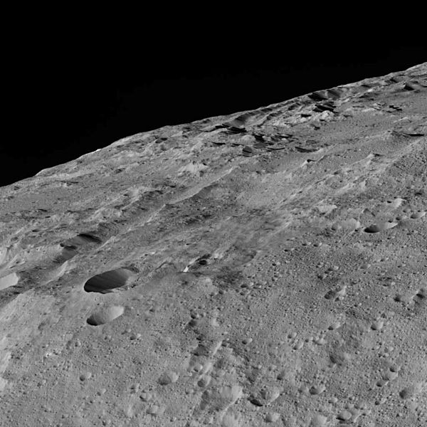
English: Original caption:
These views of Ceres, taken by NASA's Dawn spacecraft on December 10, shows an area in the southern mid-latitudes of the dwarf planet. They are located at approximately 38.1 south latitude, 209.7 east longitude, around a crater chain called Gerber Catena. Many of the troughs and grooves on Ceres were likely formed as a result of impacts, but some appear to be tectonic, reflecting internal stresses that broke the crust. A slightly different view of the same area, taken in the same sequence (Figure 1), is also available. The two views were combined to make a 3-D anaglyph (Figure 2). The spacecraft took these images in its low-altitude mapping orbit (LAMO) from an approximate distance of 240 miles (385 kilometers) from Ceres. |
| Date | |
| Source | http://photojournal.jpl.nasa.gov/catalog/PIA20186 |
| Author | NASA/JPL-Caltech/UCLA/MPS/DLR/IDA |
Licensing
[edit]
| This file is in the public domain in the United States because it was solely created by NASA. NASA copyright policy states that "NASA material is not protected by copyright unless noted". (See Template:PD-USGov, NASA copyright policy page or JPL Image Use Policy.) | ||
 |
Warnings:
|
File history
Click on a date/time to view the file as it appeared at that time.
| Date/Time | Thumbnail | Dimensions | User | Comment | |
|---|---|---|---|---|---|
| current | 18:26, 22 December 2015 | | 1,024 × 1,024 (133 KB) | Njardarlogar (talk | contribs) | User created page with UploadWizard |
You cannot overwrite this file.
File usage on Commons
There are no pages that use this file.
File usage on other wikis
The following other wikis use this file:
- Usage on nn.wikipedia.org