File:GerbTash.png
GerbTash.png (367 × 458 pixels, file size: 170 KB, MIME type: image/png)
Captions
Captions
Summary
[edit]
| Description |
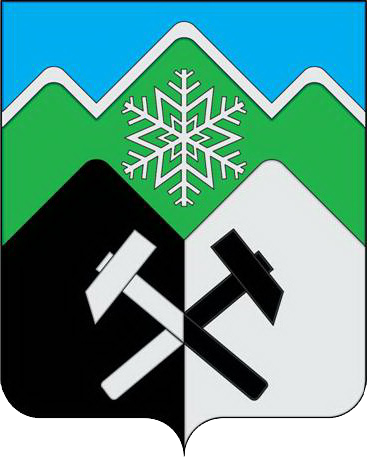
Русский: Зелёная гора о трёх вершинах символизирует горную местность, покрытую вечнозелёной тайгой, а серебряная (белая) кайма - снежный покров.
Гора чёрного цвета символизирует преобладающую отрасль хозяйствования - добычу железной руды, а серебряная (белая) гора и снежинка, аллегорически показывают развитие горнолыжного спорта и сноуборда. Перекрещённые молотки переменных цветов символизируют союз науки (серебряный) и горного дела (чёрный). Применённые в гербе цвета дополняют его символику: лазурь (синий цвет) – символ небесной чистоты, возвышенных устремлений, взаимоуважения и согласия в обществе; зеленый цвет - символ необъятных просторов тайги, роста, надежды, молодости и здоровья; чёрный цвет - символ мудрости, скромности, вечности бытия; серебро (белый цвет) – символ чистоты, открытости, божественной мудрости, мира; |
| Date | |
| Source | http://atr42.ru/index/0-7 |
| Author |
Авторская группа: идея герба сформирована инициативной группой под руководством Анянова Виктора Сергеевича 2007 г. (Таштагол); геральдическая доработка: Константин Моченов (Химки); художник и компьютерный дизайн: Ольга Салова (Москва); обоснование символики: Юрий Фрейман (Кемерово). |
Licensing
[edit]
This work is not an object of copyright according to article 1259 of Book IV of the Civil Code of the Russian Federation No. 230-FZ of December 18, 2006.
Shall not be objects of copyright:
|
 | |
|
Comment – This license tag is also applicable to official documents, state symbols and signs of the Russian Soviet Federative Socialist Republic and the Union of Soviet Socialist Republics (union level[1]).
Warning – This license tag is not applicable to drafts of official documents, proposed official symbols and signs, which can be copyrighted. Warning – This Russian official document, state symbol or sign (postage stamps, coins and banknotes mainly) may incorporate one or more works that can be copyrightable if separated from this document, symbol or sign. In such a case, this work is not an object of copyright if reused in its entirety but, at the same time, extracting specific portions from this work could constitute copyright infringement. For example, the denomination and country name must be preserved on postage stamps.
|
File history
Click on a date/time to view the file as it appeared at that time.
| Date/Time | Thumbnail | Dimensions | User | Comment | |
|---|---|---|---|---|---|
| current | 19:15, 10 March 2021 | | 367 × 458 (170 KB) | Archivarius1983 (talk | contribs) | Uploaded a work by Авторская группа: идея герба сформирована инициативной группой под руководством Анянова Виктора Сергеевича 2007 г. (Таштагол); геральдическая доработка: Константин Моченов (Химки); художник и компьютерный дизайн: Ольга Салова (Москва); обоснование символики: Юрий Фрейман (Кемерово). from http://atr42.ru/index/0-7 with UploadWizard |
You cannot overwrite this file.
File usage on Commons
The following page uses this file:
File usage on other wikis
The following other wikis use this file:
- Usage on ce.wikipedia.org
- Usage on en.wikipedia.org
- Usage on fa.wikipedia.org
- Usage on hu.wikipedia.org
- Usage on hy.wikipedia.org
- Usage on it.wikipedia.org
- Usage on ru.wikipedia.org
- Кемеровская область
- Таштагол
- Темиртау (Кемеровская область)
- Таштагольский район
- Шерегеш
- Каз (посёлок городского типа)
- Мундыбаш (посёлок городского типа)
- Административно-территориальное деление Кемеровской области
- Усть-Анзас
- Чулеш (посёлок)
- Чугунаш
- Мрассу (посёлок)
- Алтамаш
- Усть-Кабырза
- Средние Кичи
- Тельбес (посёлок)
- Петухов Лог (Кемеровская область)
- Амзас
- Кондома (посёлок)
- Чилису-Анзас
- Учулен
- Карагол
- Усть-Кезес
- Базанча (посёлок)
- Шаблон:Населённые пункты Таштагольского района
- Таска (посёлок)
- Килинск (Таштагольский район)
- 517 км
- 527 км
- 534 км
- 538 км
- 545 км
- Анзас (посёлок)
- Базарный (Кемеровская область)
- Белка (Кемеровская область)
- Берёзовая Речка (Кемеровская область)
- Ближний Кезек
- Большой Лабыш
- Верх-Кочура
- Верхние Кичи
- Верхний Алзак
- Верхний Анзас
- Верхний Бугзас
- Верхний Нымзас
View more global usage of this file.