File:George P. Coleman Memorial Bridge, Yorktown, Virginia (14422587871).jpg

Original file (4,000 × 3,000 pixels, file size: 2.66 MB, MIME type: image/jpeg)
Captions
Captions
Summary
[edit].jpg&action=edit§ion=1)
| Description |
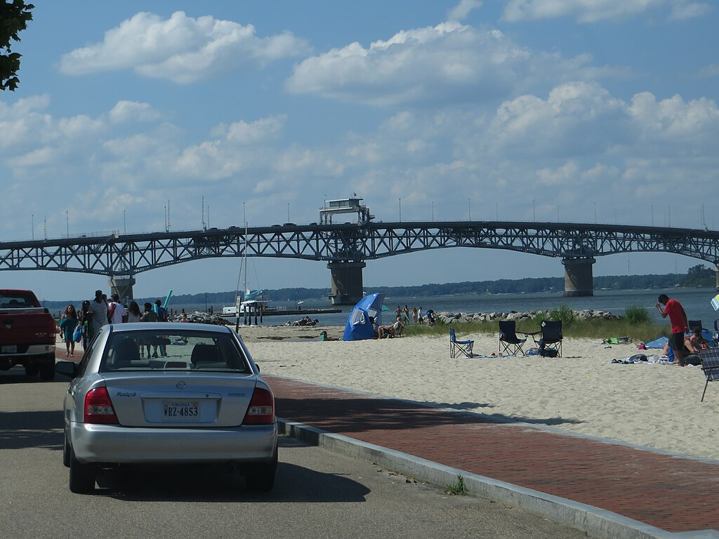
The George P. Coleman Memorial Bridge (known locally as simply the Coleman Bridge) is a double swing bridge that spans the York River between Yorktown and Gloucester Point, in the U.S. state of Virginia. It connects the Peninsula and Middle Peninsula regions of Tidewater, Virginia. The bridge is the only public crossing of the York River, though State Route 33 crosses both of its tributaries (the Mattaponi and Pamunkey Rivers) at just above its source at West Point. The current 3,750-foot (1,140 m)-long double-swing-span bridge carries U.S. Route 17, a four-lane arterial highway. The movable span is needed to allow ship access to several military installations that are upstream of the bridge, most notably, the U.S. Navy's Naval Weapons Station Yorktown. The roadways are almost 90 feet (27 m) above the river at the highest point of the bridge. The bridge is the largest double-swing-span bridge in the United States, and second largest in the world. en.wikipedia.org/wiki/George_P._Coleman_Memorial_Bridge en.wikipedia.org/wiki/Wikipedia:Text_of_Creative_Commons_... |
| Date | |
| Source | George P. Coleman Memorial Bridge, Yorktown, Virginia |
| Author | Ken Lund from Reno, Nevada, USA |
| Camera location | | View this and other nearby images on: OpenStreetMap |
|---|
.jpg¶ms=037.234669_N_-076.504703_E_globe:Earth_type:camera_source:Flickr_&language=en)
Licensing
[edit].jpg&action=edit§ion=2)
- You are free:
- to share – to copy, distribute and transmit the work
- to remix – to adapt the work
- Under the following conditions:
- attribution – You must give appropriate credit, provide a link to the license, and indicate if changes were made. You may do so in any reasonable manner, but not in any way that suggests the licensor endorses you or your use.
- share alike – If you remix, transform, or build upon the material, you must distribute your contributions under the same or compatible license as the original.
| This image was originally posted to Flickr by Ken Lund at https://flickr.com/photos/75683070@N00/14422587871. It was reviewed on 21 February 2017 by FlickreviewR and was confirmed to be licensed under the terms of the cc-by-sa-2.0. |
File history
Click on a date/time to view the file as it appeared at that time.
| Date/Time | Thumbnail | Dimensions | User | Comment | |
|---|---|---|---|---|---|
| current | 16:13, 21 February 2017 | | 4,000 × 3,000 (2.66 MB) | Ser Amantio di Nicolao (talk | contribs) | Transferred from Flickr via Flickr2Commons |
You cannot overwrite this file.
File usage on Commons
There are no pages that use this file.
.jpg&oldid=890722985)