File:Geological mapping1.gif
Jump to navigation
Jump to search
No higher resolution available.
Geological_mapping1.gif (223 × 158 pixels, file size: 9 KB, MIME type: image/gif)
Captions
Captions
Add a one-line explanation of what this file represents
Summary
[edit]
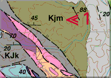
| Description | Each geologic unit on a geological map is assigned a set of letters to symbolize it on the map (for example, to the left of the red arrows at location 1). Usually the symbol is the combination of an initial capital letter followed by one or more small letters. The capital letter represents the age of the geologic unit. |
| Date | before 2000-09-26 |
| Source | http://www.nature.nps.gov/geology/usgsnps/gmap/gmap2.html |
| Author | National Park Service and Russell W. Graymer of Western Region Mapping Team, U.S. Geological Survey |
Licensing
[edit]
This image is in the public domain in the United States because it only contains materials that originally came from the United States Geological Survey, an agency of the United States Department of the Interior. For more information, see the official USGS copyright policy.
|
File history
Click on a date/time to view the file as it appeared at that time.
| Date/Time | Thumbnail | Dimensions | User | Comment | |
|---|---|---|---|---|---|
| current | 13:17, 26 January 2011 | | 223 × 158 (9 KB) | דקי (talk | contribs) |
You cannot overwrite this file.
File usage on Commons
There are no pages that use this file.
File usage on other wikis
The following other wikis use this file:
- Usage on he.wikipedia.org