File:Geolandscape sign at Arizona Snowbowl.jpg
Jump to navigation
Jump to search
Size of this preview: 800 × 534 pixels. Other resolutions: 320 × 214 pixels | 640 × 427 pixels | 1,024 × 683 pixels | 1,280 × 854 pixels | 2,560 × 1,709 pixels | 7,360 × 4,912 pixels.
Original file (7,360 × 4,912 pixels, file size: 11.1 MB, MIME type: image/jpeg)
Captions
Captions
Add a one-line explanation of what this file represents
Summary
[edit]
| Description |
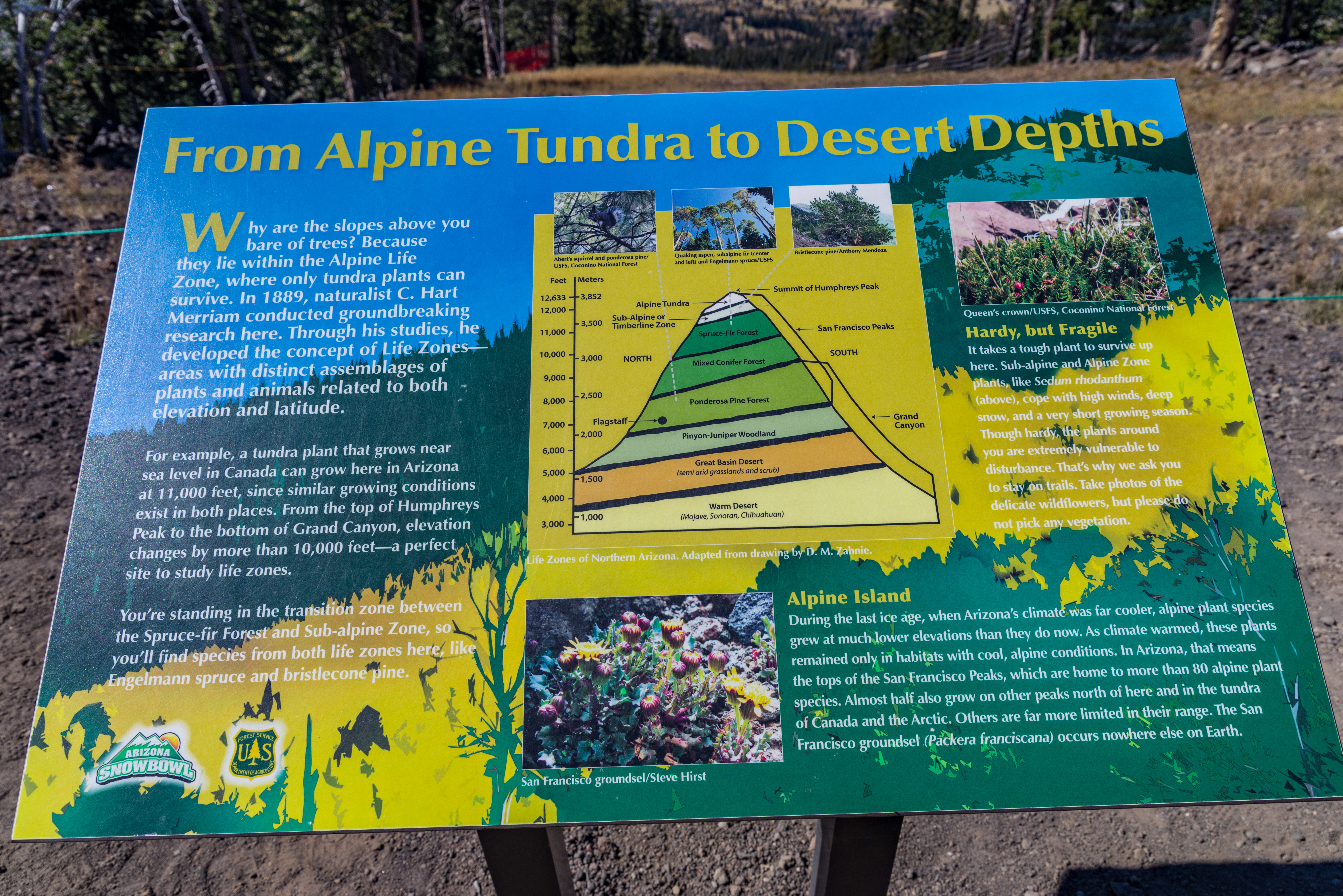
English: A sign explaining the different landscape and ecology of Northern Arizona to the deserts nearby |
| Date | |
| Source | https://www.flickr.com/photos/azcof/23869155318/in/photolist-CneEhE-ZqymDy-CneQN9-YoE22C-ZtkpbK-Z5Aj2o-Zp7pzf-YoDNb7-sHRbJM-tnzaXr-sGTzoY-tDCouS-tnpJ9j-tDYtkX-tntKU6-tByABw-sH8Hfa-to4sAj-sGUKpY-LUGn6N-MG7f1q-MJP4YB-27fjoGr-Yay5Qw-sKUFMt-tGMug8-sKTBni-UzcZrE-tq9TDW-tnpXNV-tqbniQ-UevJoq-tDxFeJ-UC6Ej4-YsdLig-YsebHZ-tw5jza-sRvqks-tvWC2w-28vGNML-Yc8ACm-YscCRK-XbrLAC-TzXwSP-Z4Z3zC-XdSHQV-tpraMj-sJyw59-tDeBSU-tFK3qB |
| Author | Coconino National Forest |
| Camera location | | View this and other nearby images on: OpenStreetMap |
|---|
Licensing
[edit]
| This image was originally posted to Flickr by AZ-COF at https://flickr.com/photos/154738375@N05/23869155318 (archive). It was reviewed on 20 December 2018 by FlickreviewR 2 and was confirmed to be licensed under the terms of the Public Domain Mark. |
This image is a work of the Forest Service of the United States Department of Agriculture. As a work of the U.S. federal government, the image is in the public domain.
|
File history
Click on a date/time to view the file as it appeared at that time.
| Date/Time | Thumbnail | Dimensions | User | Comment | |
|---|---|---|---|---|---|
| current | 19:42, 20 December 2018 | | 7,360 × 4,912 (11.1 MB) | FlickreviewR 2 (talk | contribs) | Replacing image by its original image from Flickr |
| 19:41, 20 December 2018 |  | 640 × 427 (223 KB) | Kyerjay (talk | contribs) | User created page with UploadWizard |
You cannot overwrite this file.
File usage on Commons
There are no pages that use this file.