File:Geofeatures map of Tohoku Japan ja.svg
Jump to navigation
Jump to search

Size of this PNG preview of this SVG file: 428 × 599 pixels. Other resolutions: 171 × 240 pixels | 343 × 480 pixels | 548 × 768 pixels | 731 × 1,024 pixels | 1,463 × 2,048 pixels | 1,000 × 1,400 pixels.
Original file (SVG file, nominally 1,000 × 1,400 pixels, file size: 4.05 MB)
Captions
Captions
Add a one-line explanation of what this file represents
Summary
[edit]
| Description |
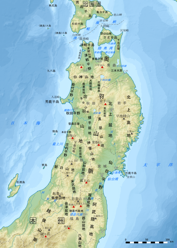
日本語: 東北地方の主要地形名(山地、平野、海域など)を示した地形図。説明:日本語。
各地形の名称と位置は原則として『新版日本国勢地図』(1990年, 国土地理院HP公開版)に準拠。山岳名や河川名、都市名など一部は電子国土基本図(地理院地図)を参照した。
English: Geographical features map of Tohoku Region in Japan with Japanese language description. |
| Date | |
| Source | File:Japan NorthernHonshu simplemap-de.svg |
| Author |
Original map:Uwe Dedering |
This W3C-unspecified vector image was created with Inkscape .
Licensing
[edit]
This file is licensed under the Creative Commons Attribution-Share Alike 3.0 Unported license.
- You are free:
- to share – to copy, distribute and transmit the work
- to remix – to adapt the work
- Under the following conditions:
- attribution – You must give appropriate credit, provide a link to the license, and indicate if changes were made. You may do so in any reasonable manner, but not in any way that suggests the licensor endorses you or your use.
- share alike – If you remix, transform, or build upon the material, you must distribute your contributions under the same or compatible license as the original.
File history
Click on a date/time to view the file as it appeared at that time.
| Date/Time | Thumbnail | Dimensions | User | Comment | |
|---|---|---|---|---|---|
| current | 05:22, 28 December 2017 | | 1,000 × 1,400 (4.05 MB) | Peka (talk | contribs) | User created page with UploadWizard |
You cannot overwrite this file.
File usage on Commons
The following 2 pages use this file:
File usage on other wikis
The following other wikis use this file:
- Usage on ca.wikipedia.org
- Usage on en.wikipedia.org
- Usage on ga.wikipedia.org
- Usage on gl.wikipedia.org
- Usage on hy.wikipedia.org
- Usage on ja.wikipedia.org
- Usage on ko.wikipedia.org
- Usage on uk.wikipedia.org
- Usage on uz.wikipedia.org
- Usage on www.wikidata.org
- Usage on zh.wikipedia.org